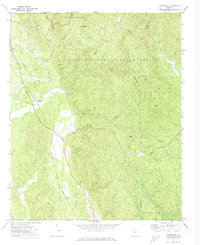
1971 Map of Ramhurst
USGS Topo · Published 1974About this map
Fort Mountain State Park and the Chattahoochee National Forest dominate the high ridges of this North Georgia landscape, where peaks like Chestnut Knob and Hightop overlook a network of creek valleys. The western corridor follows the Louisville And Nashville railroad line, linking rural communities such as Ramhurst, Dennis, and Coniston. Small country churches, including Mt Zion Ch and Mt Pisgah Ch, serve as social anchors for these valley settlements. This era of the early 1970s shows the landscape undergoing change, specifically with the blue hatching indicating areas destined to be submerged by Carters Lake at its planned elevation. The map captures the transition of the Coosawattee River basin, preserving the locations of features like Bloodtown and Ramsey Cem before the reservoir waters permanently altered the surrounding terrain.
Find a feature on this map
44 named features on this map. Tap any name to fly to it.
Don’t see what you’re looking for? This feature index may not catch every label — zoom into the map to look around manually.
Map Details
Editions of this 1971 Ramhurst Map
2 editions found
Other maps of this area

1886 · Dalton
USGS Topo · 1:125,000

1892 · Dalton
USGS Topo · 1:125,000

1897 · Dalton
USGS Topo · 1:125,000

1911 · Cohutta Mtn
USGS Topo · 1:62,500

1913 · Cohutta Mtn.
USGS Topo · 1:62,500

1914 · Talking Rock
USGS Topo · 1:62,500

1916 · Talking Rock
USGS Topo · 1:62,500

1938 · Chatsworth
USGS Topo · 1:48,000

1943 · Dalton
USGS Topo · 1:62,500
1949 · Calhoun
USGS Topo · 1:62,500