1950s Maps of Nashville, Tennessee
Explore 23 historic maps of Nashville from the 1950s. These maps offer a rare glimpse into what life looked like during the 1950s — showing old roads, neighborhoods, homes, and landmarks that have changed or disappeared over time.
Whether you're researching your family's past, planning a metal detecting trip, or studying how Nashville's landscape evolved across the 1950s, these high-resolution maps are a powerful tool for exploring the history of this region.
- Focus on a specific era: All maps on this page are from the 1950s, giving you a focused view of this time period.
- See what’s changed: Compare century-old streets, trails, and buildings to today's modern landscape using overlays and satellite layers.
- Research with precision: Use these maps for genealogy, historical research, land use analysis, or educational projects.
- View, download, or print: Maps are fully viewable online in high resolution, and can be downloaded or printed for your own records.
Start exploring Nashville's history through authentic maps from the 1950s. This is your window into the past.
Nashville, TN maps
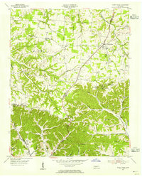
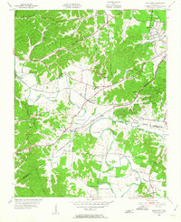
(23)- 1951 Map of Fairview, 1957 Print
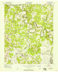
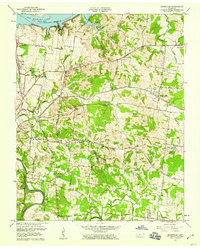
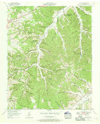 1951 Fairview1957 Print · USGSThe rural borderlands of Williamson and Davidson counties are captured here in the early 1950s, centered on the South Fork Harpeth River. Genealogists can trace family names through the McPherson Cem Graveyard, Beasley Ch, and Fernvale Sch.4 unique versions available
 - 1952 Map of Goodlettsville, 1953 Print
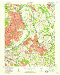
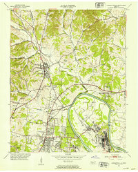 1952 Goodlettsville1953 Print · USGSNorth of Nashville in the early fifties, the landscape around the Cumberland River reflects a mix of industrial river towns and rural crossroads. Genealogists can trace family footprints through numerous local landmarks like Lumsley Church, Old Center, and the sprawling grounds of Madison College.
 - 1952 Map of Hendersonville, 1953 Print
 1952 Hendersonville1953 Print · USGSSumner County is captured here in the early fifties, before the rapid suburban expansion of the Nashville region. Genealogists can locate family landmarks such as Shackle Island, Stark Knob Ch, and the winding Walton Ferry Road along the river.
 - 1952 Map of Hermitage, 1954 Print
 1952 Hermitage1954 Print · USGSDavidson and Wilson counties are captured in the early fifties, showing the rural landscapes around the Cumberland River before significant suburban growth. Trace family roots at The Hermitage, Bakers Grove Ch, and the Confederate Memorial Cem.
 - 1952 Map of Nashville West, 1954 Print
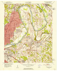
 1952 Nashville West1954 Print · USGSNashville's western corridor and the winding Cumberland River are captured here in the early fifties during a period of significant institutional growth. Researchers can locate numerous historic campuses and civic sites, including Fisk University, the State Penitentiary, and Cumberland Airfield.2 unique versions available
 - 1952 Map of La Vergne, 1954 Print
 1952 La Vergne1954 Print · USGSThe rural border of Davidson and Rutherford counties is documented here in the early fifties, showing a landscape defined by the winding Stones River. Genealogists and historians can locate numerous small burial sites like Eskridge Cem and the Slave Cem, alongside landmarks such as Sewart Air Force Base.2 unique versions available
 - 1952 Map of Nashville East, 1954 Print
 1952 Nashville East1954 Print · USGSEast Nashville and the Cumberland River are captured in the early fifties as post-war growth reaches Donelson and Inglewood. Trace family history at Mount Olivet Cemetery or locate old landmarks like the State School for the Blind and the Phosphate Mine.
 - 1952 Map of Antioch, 1954 Print
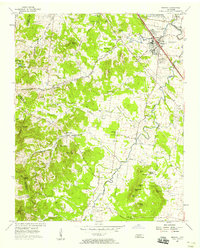
 1952 Antioch1954 Print · USGSIn the early fifties, southeast Davidson County was a landscape of expanding rail hubs and rural crossroads. Researchers can trace the layout of Radnor yards, the original Nashville Municipal Airport (Berry Field), and community landmarks like Antioch and Whitsetts Cem.2 unique versions available
 - 1953 Map of Oak Hill, 1954 Print
 1953 Oak Hill1954 Print · USGSSouth of Nashville in the early fifties, this area shows a landscape of growing suburbs and institutional landmarks before the interstate era. Genealogists and historians can trace family locations near Woodlawn Cem, Robertson Academy, and Brentwood Sta.2 unique versions available
 - 1954 Map of White House, 1955 Print
 1954 White House1955 Print · USGSThe Tennessee borderlands of Robertson and Sumner counties are captured here in the mid-1950s. Family researchers can trace dozens of homesteads and burial grounds like the Strickland Cem, alongside landmarks such as Indian Cave and White House.4 unique versions available
 - 1955 Map of Whites Creek, 1956 Print
 1955 Whites Creek1956 Print · USGSDavidson County north of Nashville was a landscape of steep ridges and deep hollows in the mid-1950s. Family historians can trace ancestral lands through named features like Bennett Hollow or find rural landmarks like Union Hill Ch and Joelton.4 unique versions available
 - 1955 Map of Forest Grove, 1956 Print
 1955 Forest Grove1956 Print · USGSNorthwest of Nashville in the mid-fifties, this area shows a rural landscape of ridges and hollows defined by the meeting of three counties. Genealogists can trace family landmarks like Gupton Cem, New Hope Ch, and the small settlement of Morny.5 unique versions available
 - 1955 Map of Scottsboro, 1956 Print
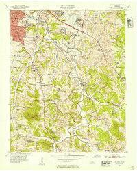
 1955 Scottsboro1956 Print · USGSThe Cumberland River bends through western Davidson County in the mid-fifties, revealing a landscape of rural schoolhouses and riverside bends. Local researchers can trace family roots at New Bethel Ch, Wade Sch, and the grounds of the State Penitentiary.
 - 1955 Map of Belleview, 1956 Print
 1955 Belleview1956 Print · USGSDavidson County in the mid-fifties remains a landscape of winding river bends and rural crossroads as the suburbs begin to stir. Genealogists and historians can trace family locations through landmarks like Ash Grove Ch, Gower Sch, and the winding Harpeth River.2 unique versions available
 - 1956 Map of Columbia, 1960 Print
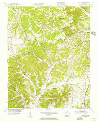
 1956 Columbia1960 Print · USGSMiddle Tennessee in the mid-fifties presents a landscape of established river towns and critical rail hubs before the arrival of the modern interstate system. Researchers can trace the routes of the Louisville and Nashville railroad or locate historic landmarks like Stones River National Military Park and the Tennessee National Wildlife Refuge.6 unique versions available
 - 1956 Map of Nashville, 1971 Print
 1956 Nashville1971 Print · USGSThe Tennessee-Kentucky borderlands come into focus in the mid-1960s as major reservoir projects transformed the Cumberland and Tennessee river valleys. Researchers can trace the rail networks of the Louisville and Nashville and visit sites like Fort Campbell and Fort Donelson National Military Park.2 unique versions available
 - 1957 Map of Smyrna, 1958 Print
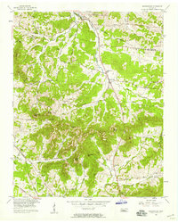
 1957 Smyrna1958 Print · USGSSmyrna and northern Rutherford County are captured here in the late fifties as rural life met the expansion of the Sewart Air Force Base. Trace family landmarks like the Sam Davis Home, Rosenwald Sch, and the Mapleview Cem.4 unique versions available
 - 1957 Map of Nolensville, 1958 Print
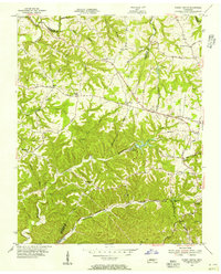
 1957 Nolensville1958 Print · USGSMid-century Williamson and Davidson Counties reveal a landscape of family farms and rural churches before modern development. Genealogists can trace ancestral ties through Battle Cem, Pettus Cem, and community centers like Nolensville School.4 unique versions available
 - 1957 Map of Hendersonville, 1959 Print
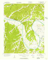
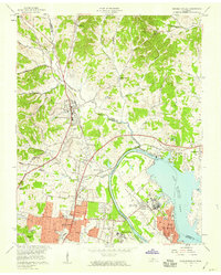
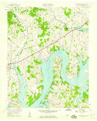 1957 Hendersonville1959 Print · USGSSumner County underwent a massive geographical shift in the late fifties as the rising Cumberland River filled the new reservoir. Researchers can trace the mid-century shoreline of Old Hickory Lake and locate old rural landmarks like Rehoboth Ch and Beech Sch.
 - 1957 Map of Hermitage, 1959 Print
 1957 Hermitage1959 Print · USGSNear Nashville in the late fifties, the landscape around The Hermitage reflects a mix of historic estates and new river reservoirs. Genealogists can trace family landmarks like the Confederate Memorial Cem, Hays Cem, and the rural Bakers Grove Ch.
 - 1957 Map of Nashville East, 1959 Print
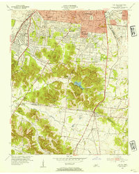
 1957 Nashville East1959 Print · USGSEast Nashville and the surrounding river bends are captured here in the late fifties as suburban growth began to surround historic riverside institutions. Researchers can trace the development of Donelson, locate family plots in Mount Olivet Cemetery, or study the early layout of Berry Field.2 unique versions available
 - 1957 Map of Goodlettsville, 1959 Print
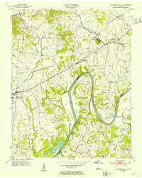
 1957 Goodlettsville1959 Print · USGSThe Cumberland River valley undergoes a mid-century transformation as the new reservoir fills behind Old Hickory Dam. Genealogists and local historians can trace the development of Goodlettsville and Madison, locating Madison College, Amqui, and the Forest Lawn Memorial Cem.
 - 1959 Map of Nashville
 1959 Nashville1959 Print · USGSMiddle Tennessee and Southern Kentucky come into focus during the late fifties, showing the region's transition into a modern transportation and military hub. Researchers can trace the sprawling Fort Campbell Military Reservation or locate historic rail stops along the Tennessee Central Ry and Illinois Central RR.
End of results
Showing maps 1-23 of 23
Top cities near Nashville
- Franklin historical maps
- Hendersonville historical maps
- Smyrna historical maps
- Brentwood historical maps
- La Vergne historical maps
- North Nashville historical maps
See more
Top neighborhoods of Nashville
- Town Park Estates historical maps
- Barclay Square historical maps
- Antioch historical maps
- Antioch Park historical maps
- Green Hills historical maps
- Huntington Ridge Estates historical maps
See more
Frequently asked questions
- What are the different types of historical maps available for Nashville?
- What is the oldest map of Nashville?
- Where can I purchase historical maps of Nashville for my home or office?
- Where can I download high-res historical maps of Nashville?
- Are there historical topographic maps available for Nashville?
- Is there historical aerial imagery available for Nashville?
- Where are historical maps of Nashville sourced from?