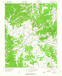
1955 Map of Belleview
USGS Topo · Published 1956About this map
The Harpeth River carves a series of dramatic loops across this mid-century landscape, creating distinct landforms like Hutton Bend, Hows Bend, and Beech Bend. This 1955 survey captures the rural character of Davidson County before the significant expansion of Nashville, centering on the community of Belleview (Bellevue Sta). The area is defined by its educational and spiritual centers, such as Bellevue High Sch, Harpeth Valley Sch, and Shiloh Ch.
Find a feature on this map
73 named features on this map. Tap any name to fly to it.
Don’t see what you’re looking for? This feature index may not catch every label — zoom into the map to look around manually.
Map Details
Editions of this 1955 Belleview Map
2 editions found
Other maps of this area

1901 · Colombia
USGS Topo · 1:125,000

1903 · Nashville
USGS Topo · 1:125,000

1909 · Franklin
USGS Topo · 1:62,500

1930 · White Bluff
USGS Topo · 1:62,500

1932 · Nashville
USGS Topo · 1:62,500

1933 · White Bluff
USGS Topo · 1:62,500

1946 · Leipers Fork
USGS Topo · 1:24,000

1949 · Leipers Fork
USGS Topo · 1:24,000

1949 · Franklin
USGS Topo · 1:24,000

1951 · Fairview
USGS Topo · 1:24,000