
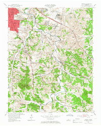
1952 Map of Antioch
USGS Topo · Published 1954About this map
Nashville Municipal Airport (Berry Field) and the Central State Hospital complex dominate the northern portion of this landscape, just before the significant suburban expansion into southeast Davidson County. The Nashville Chattanooga and St Louis railroad corridor serves as a primary axis, connecting the industrial and residential neighborhood of Woodbine and the extensive rail yards at Radnor to the community of Antioch.
Find a feature on this map
60 named features on this map. Tap any name to fly to it.
Don’t see what you’re looking for? This feature index may not catch every label — zoom into the map to look around manually.
Map Details
Editions of this 1952 Antioch Map
2 editions found
Other maps of this area

1903 · Nashville
USGS Topo · 1:125,000

1909 · Franklin
USGS Topo · 1:62,500

1932 · Hermitage
USGS Topo · 1:62,500

1932 · Nashville
USGS Topo · 1:62,500

1942 · Lebanon
USGS Topo · 1:100,000

1949 · Franklin
USGS Topo · 1:24,000

1952 · Hermitage
USGS Topo · 1:24,000

1952 · Nashville West
USGS Topo · 1:24,000

1952 · La Vergne
USGS Topo · 1:24,000

1952 · Nashville East
USGS Topo · 1:24,000