1930s Maps of Decatur County, Tennessee
Explore 11 historic maps of Decatur County from the 1930s. These maps offer a rare glimpse into what life looked like during the 1930s — showing old roads, neighborhoods, homes, and landmarks that have changed or disappeared over time.
Whether you're researching your family's past, planning a metal detecting trip, or studying how Decatur County's landscape evolved across the 1930s, these high-resolution maps are a powerful tool for exploring the history of this region.
- Focus on a specific era: All maps on this page are from the 1930s, giving you a focused view of this time period.
- See what’s changed: Compare century-old streets, trails, and buildings to today's modern landscape using overlays and satellite layers.
- Research with precision: Use these maps for genealogy, historical research, land use analysis, or educational projects.
- View, download, or print: Maps are fully viewable online in high resolution, and can be downloaded or printed for your own records.
Start exploring Decatur County's history through authentic maps from the 1930s. This is your window into the past.
Decatur County, TN maps
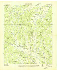
(11)- 1936 Map of Scotts Hill
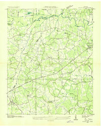 1936 Scotts Hill1936 Print · USGSHenderson and Decatur counties appear here in the mid-1930s, showing a rural landscape before modern development altered the river valleys. Researchers can locate many vanished community hubs like Dixie Mills, the County Farm, and New Hope Ch.
 - 1936 Map of Parsons
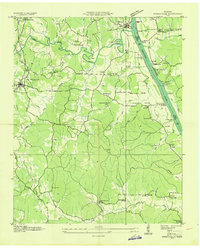
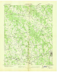 1936 Parsons1936 Print · USGSDecatur and Henderson counties are captured here in the mid-1930s, showing a landscape defined by the Nashville Chattanooga and St Louis Railway. Trace family history across rural settlements and landmarks like Old Safford, Wilkinstown, and the Cedar Hill Ch & Cem.
 - 1936 Map of Thurman
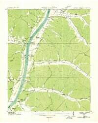
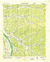
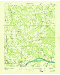 1936 Thurman1936 Print · USGSThe Tennessee River valley at Pitts Bend is captured here in the mid-thirties, showing a landscape of riverfront landings and upland farms. Genealogists can trace family names at Altillo Cem and Bethel Cem or find old school sites like Doe Creek Sch.
 - 1936 Map of Bath Springs
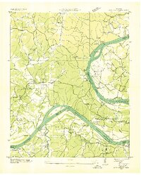 1936 Bath Springs1936 Print · USGSThe Tennessee River valley in the mid-1930s was a landscape defined by its river landings and rural crossroads. You can trace dozens of historic river access points like Furnace Landing and Jeter Landing alongside local landmarks like Bath Springs Ch.
 - 1936 Map of Daniels Landing
 1936 Daniels Landing1936 Print · USGSLife along the Tennessee River in the mid-1930s was defined by its landings and creek-side communities before major dam projects altered the valley. Genealogists can trace family landmarks like Britt Chapel Cem, Daniels Landing, and the school at Oakview Sch.
 - 1936 Map of Clifton
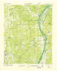
 1936 Clifton1936 Print · USGSThe Tennessee River corridor around Clifton was a network of active landings and rural ridge communities during the mid-1930s. Researchers can trace ancestral locations through several family-named cemeteries like Tucker Cem and Prater Cem, or map old river crossings such as Clifton Ferry.
 - 1936 Map of Jeannette
 1936 Jeannette1936 Print · USGSDecatur County's riverbank communities and hills are captured here in the mid-thirties as the Tennessee River valley underwent significant change. Genealogists and historians can locate family landmarks like Walker Cem and trace the paths to Busseltown or Bells Store.
 - 1936 Map of Sugar Tree
 1936 Sugar Tree1936 Print · USGSDecatur and Benton counties are shown in the mid-thirties just as the TVA began its work along the river. Researchers can locate numerous family-named landmarks and community centers such as McIlwain, Hartley Cem, and Moore Chapel Sch.
 - 1936 Map of Cavvia
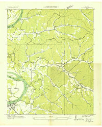
 1936 Cavvia1936 Print · USGSWest Tennessee rural life is captured in the mid-1930s where four counties converge among the forks of Birdsong and Cub Creeks. Researchers can trace ancestral locations at Shiloh Cem, identify vanished schoolhouse sites like Unity Sch, or locate old commercial hubs such as Tolleys Store.
 - 1936 Map of Perryville
 1936 Perryville1936 Print · USGSDecatur County at the height of the Great Depression shows a river-dependent landscape centered on the Tennessee River. Researchers can locate several river landings and crossings, including Perryville Ferry and Mt Zion Cem.
 - 1936 Map of Pope
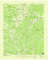
 1936 Pope1936 Print · USGSAlong the banks of the Tennessee River in the mid-1930s, this area supported a network of river landings and small valley settlements. Genealogists and historians can locate family-named landmarks like Simmons Cem, trace the location of the Old Furnace, and identify rural schools such as Gumdale Sch.
End of results
Showing maps 1-11 of 11
Top cities of Decatur County
Frequently asked questions
- What are the different types of historical maps available for Decatur County?
- What is the oldest map of Decatur County?
- Where can I purchase historical maps of Decatur County for my home or office?
- Where can I download high-res historical maps of Decatur County?
- Are there historical topographic maps available for Decatur County?
- Is there historical aerial imagery available for Decatur County?
- Where are historical maps of Decatur County sourced from?