1970s Maps of Grundy County, Tennessee
Explore 3 historic maps of Grundy County from the 1970s. These maps offer a rare glimpse into what life looked like during the 1970s — showing old roads, neighborhoods, homes, and landmarks that have changed or disappeared over time.
Whether you're researching your family's past, planning a metal detecting trip, or studying how Grundy County's landscape evolved across the 1970s, these high-resolution maps are a powerful tool for exploring the history of this region.
- Focus on a specific era: All maps on this page are from the 1970s, giving you a focused view of this time period.
- See what’s changed: Compare century-old streets, trails, and buildings to today's modern landscape using overlays and satellite layers.
- Research with precision: Use these maps for genealogy, historical research, land use analysis, or educational projects.
- View, download, or print: Maps are fully viewable online in high resolution, and can be downloaded or printed for your own records.
Start exploring Grundy County's history through authentic maps from the 1970s. This is your window into the past.
Grundy County, TN maps
(3)- 1974 Map of Monteagle, 1977 Print
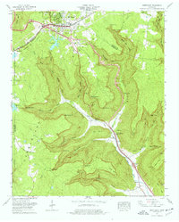 1974 Monteagle1977 Print · USGSThe Cumberland Plateau and its deep coves are captured in the mid-seventies as industry and transport met the plateau edge. Trace family roots at Trussell Cem or Martin Cem, and locate landmarks like Saltpeter Cave and the Louisville and Nashville line.3 unique versions available
 - 1974 Map of Sewanee, 1977 Print
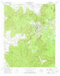 1974 Sewanee1977 Print · USGSSewanee and the plateau communities of Franklin County are captured here in the mid-seventies, centered on the University of the South. Researchers can trace old family names and landmarks from Montgomery Cem to the tracks of the Louisville and Nashville Railroad.2 unique versions available
 - 1979 Map of Chattanooga, 1980 Print
 1979 Chattanooga1980 Print · USGSSoutheast Tennessee in the late seventies reveals a landscape shaped by massive TVA river projects and the industrial strength of the Cumberland Plateau. Genealogists and historians can trace the rail-to-river network through L & N RR junctions, the University of the South, and the Volunteer Army Ammunition Plant.
End of results
Showing maps 1-3 of 3
Top cities of Grundy County
- Gruetli-Laager historical maps
- Tracy City historical maps
- Altamont historical maps
- Coalmont historical maps
- Palmer historical maps
- Beersheba Springs historical maps
Frequently asked questions
- What are the different types of historical maps available for Grundy County?
- What is the oldest map of Grundy County?
- Where can I purchase historical maps of Grundy County for my home or office?
- Where can I download high-res historical maps of Grundy County?
- Are there historical topographic maps available for Grundy County?
- Is there historical aerial imagery available for Grundy County?
- Where are historical maps of Grundy County sourced from?