1960s Maps of Grundy County, Tennessee
Explore 4 historic maps of Grundy County from the 1960s. These maps offer a rare glimpse into what life looked like during the 1960s — showing old roads, neighborhoods, homes, and landmarks that have changed or disappeared over time.
Whether you're researching your family's past, planning a metal detecting trip, or studying how Grundy County's landscape evolved across the 1960s, these high-resolution maps are a powerful tool for exploring the history of this region.
- Focus on a specific era: All maps on this page are from the 1960s, giving you a focused view of this time period.
- See what’s changed: Compare century-old streets, trails, and buildings to today's modern landscape using overlays and satellite layers.
- Research with precision: Use these maps for genealogy, historical research, land use analysis, or educational projects.
- View, download, or print: Maps are fully viewable online in high resolution, and can be downloaded or printed for your own records.
Start exploring Grundy County's history through authentic maps from the 1960s. This is your window into the past.
Grundy County, TN maps
(4)- 1960 Map of Chattanooga
 1960 Chattanooga1960 Print · USGSSoutheast Tennessee and the southern Appalachians are shown here at the height of the river-management era. You can trace the valley rail lines and locate Lookout Mountain and the expansive waters of Chickamauga Reservoir.
 - 1960 Map of Curtistown, 1961 Print
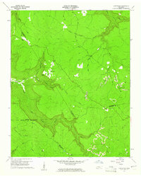 1960 Curtistown1961 Print · USGSThe Tennessee Plateau at the start of the 1960s reveals a landscape defined by isolated settlements and a rugged river-carved geography. Researchers can trace rural lineages at Pleasant Hill Cem or explore the mid-century industrial footprint of Strip Mines and the Old Target Area.3 unique versions available
 - 1960 Map of Irving College, 1962 Print
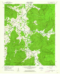 1960 Irving College1962 Print · USGSThe Collins River valley in Warren County comes to life in the early 1960s, showing a landscape defined by riverside settlements and high timbered ridges. Researchers can locate remote landmarks like Badger Mine, Camp Woodlee, and rural churches such as Philadelphia Ch.4 unique versions available
 - 1964 Map of Chattanooga
 1964 Chattanooga1964 Print · USGSSoutheast Tennessee and the western Carolinas appear in the mid-sixties as a powerhouse of river-driven industry and mountain wilderness. Genealogists and historians can trace rail-town lineages along the Southern Ry or locate family landmarks near Watts Bar Lake and Tellico Plains.
End of results
Showing maps 1-4 of 4
Top cities of Grundy County
- Gruetli-Laager historical maps
- Tracy City historical maps
- Altamont historical maps
- Coalmont historical maps
- Palmer historical maps
- Beersheba Springs historical maps
Frequently asked questions
- What are the different types of historical maps available for Grundy County?
- What is the oldest map of Grundy County?
- Where can I purchase historical maps of Grundy County for my home or office?
- Where can I download high-res historical maps of Grundy County?
- Are there historical topographic maps available for Grundy County?
- Is there historical aerial imagery available for Grundy County?
- Where are historical maps of Grundy County sourced from?