1930s Maps of Lankford Town, Tennessee
Explore 1 historic maps of Lankford Town from the 1930s. These maps offer a rare glimpse into what life looked like during the 1930s — showing old roads, neighborhoods, homes, and landmarks that have changed or disappeared over time.
Whether you're researching your family's past, planning a metal detecting trip, or studying how Lankford Town's landscape evolved across the 1930s, these high-resolution maps are a powerful tool for exploring the history of this region.
- Focus on a specific era: All maps on this page are from the 1930s, giving you a focused view of this time period.
- See what’s changed: Compare century-old streets, trails, and buildings to today's modern landscape using overlays and satellite layers.
- Research with precision: Use these maps for genealogy, historical research, land use analysis, or educational projects.
- View, download, or print: Maps are fully viewable online in high resolution, and can be downloaded or printed for your own records.
Start exploring Lankford Town's history through authentic maps from the 1930s. This is your window into the past.
Lankford Town, TN maps
(1)- 1936 Map of White City
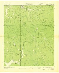 1936 White City1936 Print · USGSMarion and Grundy Counties were still defined by remote plateau life and timber or mining interests in the mid-1930s. Genealogists can locate family homesites near White City, Lankford Town, or rural schools like Prior Sch and Foster Falls Sch.
End of results
Showing maps 1-1 of 1
Top cities near Lankford Town
- South Pittsburg historical maps
- Jasper historical maps
- Sewanee historical maps
- Gruetli-Laager historical maps
- Tracy City historical maps
- Whitwell historical maps
See more
Frequently asked questions
- What are the different types of historical maps available for Lankford Town?
- What is the oldest map of Lankford Town?
- Where can I purchase historical maps of Lankford Town for my home or office?
- Where can I download high-res historical maps of Lankford Town?
- Are there historical topographic maps available for Lankford Town?
- Is there historical aerial imagery available for Lankford Town?
- Where are historical maps of Lankford Town sourced from?