1950s Maps of Henry County, Tennessee
Explore 21 historic maps of Henry County from the 1950s. These maps offer a rare glimpse into what life looked like during the 1950s — showing old roads, neighborhoods, homes, and landmarks that have changed or disappeared over time.
Whether you're researching your family's past, planning a metal detecting trip, or studying how Henry County's landscape evolved across the 1950s, these high-resolution maps are a powerful tool for exploring the history of this region.
- Focus on a specific era: All maps on this page are from the 1950s, giving you a focused view of this time period.
- See what’s changed: Compare century-old streets, trails, and buildings to today's modern landscape using overlays and satellite layers.
- Research with precision: Use these maps for genealogy, historical research, land use analysis, or educational projects.
- View, download, or print: Maps are fully viewable online in high resolution, and can be downloaded or printed for your own records.
Start exploring Henry County's history through authentic maps from the 1950s. This is your window into the past.
Henry County, TN maps
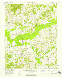
(21)- 1950 Map of Osage
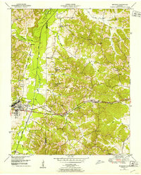
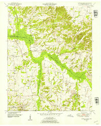
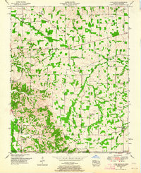
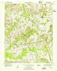 1950 Osage1950 Print · USGSHenry County in the early fifties shows a landscape of established farmsteads and rural social centers. Genealogists can trace family names through dozens of landmarks like Central Point School, Oak Hill Church, and the Palestine Cem burial grounds.3 unique versions available
 - 1950 Map of Paris
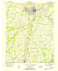
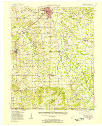
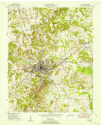 1950 Paris1950 Print · USGSMid-century Paris, Tennessee, thrived as a vital railroad crossroads where two major lines intersected amidst the ridges of the Tennessee Valley Divide. Genealogists can trace family roots through numerous sites like Jones Chapel, Greenwood Cem, and the Nelson Sch.
 - 1950 Map of Buchanan, 1953 Print
 1950 Buchanan1953 Print · USGSThe Kentucky-Tennessee line comes alive in the early fifties, showing a rural landscape shaped by the new Kentucky Lake. Genealogists can trace family names at Buchanan Cem, Mt Zion Ch, and the small community of Freeland.2 unique versions available
 - 1950 Map of Big Sandy, 1953 Print
 1950 Big Sandy1953 Print · USGSThe Tennessee riverfront near the Big Sandy settlement and the newly formed Kentucky Lake appears here in the early fifties. Genealogists and local historians can trace rural family life through landmarks like McRae Chapel, Morgan Claxton School, and Baker Chapel Cem.3 unique versions available
 - 1950 Map of Bruceton, 1953 Print
 1950 Bruceton1953 Print · USGSBruceton and the surrounding Tennessee lowlands appear here in the early 1950s, showing a landscape defined by the Nashville Chattanooga and St Louis railway. Local historians can trace old landmarks like Sawyers Mill, Sandy Point Sch, and the historical path of the Natchez Trace.3 unique versions available
 - 1950 Map of Paris Landing, 1953 Print
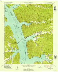
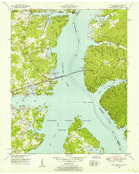 1950 Paris Landing1953 Print · USGSKentucky Lake and the Tennessee River valley are shown here just as the post-war recreational and conservation landscape began to take shape. Researchers can locate family homesteads near Old Liberty Ch, Bradford Cem, and the Cypress Creek Cabin Area.5 unique versions available
 - 1950 Map of Mansfield, 1953 Print
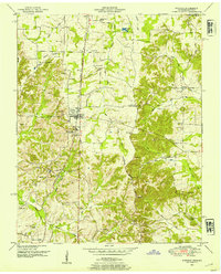
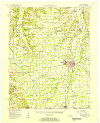
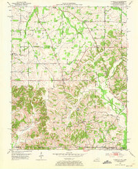
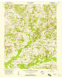
 1950 Mansfield1953 Print · USGSHenry and Carroll counties are captured here in the early fifties, showcasing a rural landscape defined by the Tennessee Valley Divide. Researchers can trace old family sites like Dumpling Hill Cem and settlements at Mansfield and Routon.3 unique versions available
 - 1950 Map of Puryear, 1954 Print
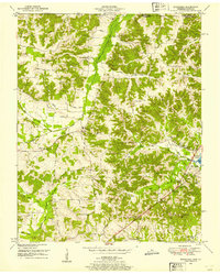
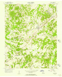
 1950 Puryear1954 Print · USGSHenry County and the Kentucky borderlands are captured here in the early fifties as rural life centered on the railroad. Genealogists can locate numerous family sites like Underwood Cem, Bradley Cem, and the old community at Conyersville.3 unique versions available
 - 1950 Map of Cottage Grove, 1954 Print
 1950 Cottage Grove1954 Print · USGSHenry County is captured in the early postwar years as a landscape of small family farms and dispersed rural crossroads. Genealogists can trace hundreds of local landmarks, from the Cottage Grove settlement to Dogwood Sch and dozens of family-named cemeteries like Kuykendall Cem.3 unique versions available
 - 1950 Map of Mc Kinnon, 1954 Print
 1950 Mc Kinnon1954 Print · USGSThe Tennessee River valley is shown shortly after the creation of Kentucky Lake, when the rising waters reshaped local life. Genealogists and historians can trace numerous family burial sites like Wynns Cem and rail-era landmarks such as the Louisville and Nashville line and McKinnon.3 unique versions available
 - 1951 Map of Hazel, 1955 Print
 1951 Hazel1955 Print · USGSCalloway County at the start of the 1950s shows a landscape of growing college towns and quiet rural junctions. Researchers can trace the Nashville Chattanooga and St Louis rail line through Midway and find local landmarks like Old Salem Ch and England Cem.2 unique versions available
 - 1951 Map of Murray, 1957 Print
 1951 Murray1957 Print · USGSMid-century Calloway County centers on the growing campus of Murray State Teachers College and the vital Nashville Chattanooga and St Louis rail line. Researchers can trace rural family sites at Taylors Store, Backusburg, and the many cemeteries like Bazzell Cem scattered across the Tennessee Valley Divide.
 - 1951 Map of Lynn Grove, 1964 Print
 1951 Lynn Grove1964 Print · USGSCalloway County and the Tennessee borderlands appear here in the early 1950s, a rural landscape shaped by the Tennessee Valley Divide. Researchers can trace old family sites near Lynn Grove, Wiswell, and Taylors Store, or find local heritage at Sinking Spring Church and Brush Island Cem.2 unique versions available
 - 1952 Map of Mayfield, 1957 Print
 1952 Mayfield1957 Print · USGSGraves County, Kentucky, was a bustling network of rail-side towns and rural parishes at the mid-century. Researchers can trace family history through dozens of landmarks like Rozzell Cem, follow the Illinois Central Railroad, or locate the County Farm.
 - 1952 Map of Lynnville, 1973 Print
 1952 Lynnville1973 Print · USGSSouthern Graves County and the Tennessee borderlands are captured in the early fifties, showing a landscape defined by small farming hamlets and family homesteads. Genealogists can trace rural lifelines through sites like Burnett Chapel, Cuba High Sch, and dozens of burial grounds like Tibbs Cem.
 - 1955 Map of Henry, 1957 Print
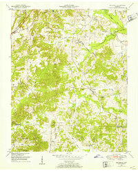
 1955 Henry1957 Print · USGSHenry and the surrounding countryside are shown in the mid-1950s as the railroad and small-town schools shaped West Tennessee life. Genealogists can trace family landmarks like Dillahunty Cem and Caton Springs Cem, or find old gathering places such as Salem Ch.3 unique versions available
 - 1956 Map of Palmersville, 1958 Print
 1956 Palmersville1958 Print · USGSThe rural landscape around Palmersville comes alive in this mid-century survey of Weakley County. Genealogists can trace family names through dozens of landmarks like Union Hall Ch, Palmer Cem, and the Union No 1 Sch.2 unique versions available
 - 1956 Map of Dyersburg, 1960 Print
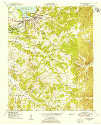
 1956 Dyersburg1960 Print · USGSThe Four Rivers region comes alive in the mid-fifties, capturing the intricate borderlands of Tennessee, Kentucky, and Missouri. Genealogists and historians can trace the rail-and-river networks connecting Dyersburg, Caruthersville, and the shoreline of Reelfoot Lake.4 unique versions available
 - 1956 Map of Nashville, 1971 Print
 1956 Nashville1971 Print · USGSThe Tennessee-Kentucky borderlands come into focus in the mid-1960s as major reservoir projects transformed the Cumberland and Tennessee river valleys. Researchers can trace the rail networks of the Louisville and Nashville and visit sites like Fort Campbell and Fort Donelson National Military Park.2 unique versions available
 - 1957 Map of Como, 1958 Print
 1957 Como1958 Print · USGSWeakley County at the end of the post-war decade is a landscape of tight-knit rural communities and family farms. Researchers can trace ancestral locations through numerous landmarks like Wesleys Chapel, Owens Cem, and the settlement of Ore Springs.3 unique versions available
 - 1959 Map of Nashville
 1959 Nashville1959 Print · USGSMiddle Tennessee and Southern Kentucky come into focus during the late fifties, showing the region's transition into a modern transportation and military hub. Researchers can trace the sprawling Fort Campbell Military Reservation or locate historic rail stops along the Tennessee Central Ry and Illinois Central RR.
End of results
Showing maps 1-21 of 21
Top cities of Henry County
Frequently asked questions
- What are the different types of historical maps available for Henry County?
- What is the oldest map of Henry County?
- Where can I purchase historical maps of Henry County for my home or office?
- Where can I download high-res historical maps of Henry County?
- Are there historical topographic maps available for Henry County?
- Is there historical aerial imagery available for Henry County?
- Where are historical maps of Henry County sourced from?