1960s Maps of Henry County, Tennessee
Explore 5 historic maps of Henry County from the 1960s. These maps offer a rare glimpse into what life looked like during the 1960s — showing old roads, neighborhoods, homes, and landmarks that have changed or disappeared over time.
Whether you're researching your family's past, planning a metal detecting trip, or studying how Henry County's landscape evolved across the 1960s, these high-resolution maps are a powerful tool for exploring the history of this region.
- Focus on a specific era: All maps on this page are from the 1960s, giving you a focused view of this time period.
- See what’s changed: Compare century-old streets, trails, and buildings to today's modern landscape using overlays and satellite layers.
- Research with precision: Use these maps for genealogy, historical research, land use analysis, or educational projects.
- View, download, or print: Maps are fully viewable online in high resolution, and can be downloaded or printed for your own records.
Start exploring Henry County's history through authentic maps from the 1960s. This is your window into the past.
Henry County, TN maps
(5)- 1965 Map of Paris, 1967 Print
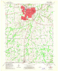
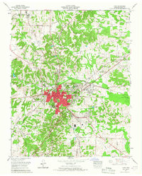 1965 Paris1967 Print · USGSMid-century Henry County centers on the thriving rail hub of Paris as it expands into new residential tracts. Researchers can trace family roots at Maplewood Cem, find the old Rowe School, and locate rural landmarks like India and Birds Creek Church.2 unique versions available
 - 1965 Map of Manleyville, 1967 Print
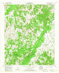 1965 Manleyville1967 Print · USGSThe rural uplands of Henry County meet the engineered bottomlands of the Big Sandy River in the mid-1960s. Genealogists can trace family landmarks like Rowden Cem and Manleys Chapel Cem, while historians can locate the Reynoldsburg Road and the Big Sandy River Dewatering Area.2 unique versions available
 - 1965 Map of West Sandy Dike, 1967 Print
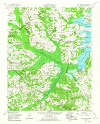 1965 West Sandy Dike1967 Print · USGSHenry County territory near the Kentucky border comes into focus in the mid-sixties, showing the Tennessee Valley Authority's impact on the local landscape. Researchers can trace family sites like Old Springville, find numerous family burial grounds including Wright Cem, and locate the Dismantled RR corridor.2 unique versions available
 - 1967 Map of Mc Kenzie, 1969 Print
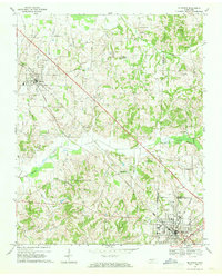 1967 Mc Kenzie1969 Print · USGSThe rural landscape around McKenzie and Gleason is captured here in the late sixties, where three counties meet along the Louisville and Nashville line. Researchers can trace the grounds of Bethel College and find local landmarks like Tumbling Creek Cem and Everett Chapel.2 unique versions available
 - 1969 Map of Murray, 1970 Print
 1969 Murray1970 Print · USGSCalloway County and the Kentucky-Tennessee borderland are captured here during a period of significant educational and civic growth. Genealogists can trace family names through rural landmarks like Old Salem Cem, Green Plains Ch, and the town of Hazel on the state line.3 unique versions available
End of results
Showing maps 1-5 of 5
Top cities of Henry County
Frequently asked questions
- What are the different types of historical maps available for Henry County?
- What is the oldest map of Henry County?
- Where can I purchase historical maps of Henry County for my home or office?
- Where can I download high-res historical maps of Henry County?
- Are there historical topographic maps available for Henry County?
- Is there historical aerial imagery available for Henry County?
- Where are historical maps of Henry County sourced from?