1900s (20th Century) Maps of New Hope, Tennessee
Explore 28 historic maps of New Hope from the 1900s (20th Century). These maps offer a rare glimpse into what life looked like during the 1900s — showing old roads, neighborhoods, homes, and landmarks that have changed or disappeared over time.
Whether you're researching your family's past, planning a metal detecting trip, or studying how New Hope's landscape evolved across the 1900s, these high-resolution maps are a powerful tool for exploring the history of this region.
- Focus on a specific era: All maps on this page are from the 1900s, giving you a focused view of this time period.
- See what’s changed: Compare century-old streets, trails, and buildings to today's modern landscape using overlays and satellite layers.
- Research with precision: Use these maps for genealogy, historical research, land use analysis, or educational projects.
- View, download, or print: Maps are fully viewable online in high resolution, and can be downloaded or printed for your own records.
Start exploring New Hope's history through authentic maps from the 1900s. This is your window into the past.
New Hope, TN maps
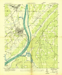
(28)- 1936 Map of Shellmound
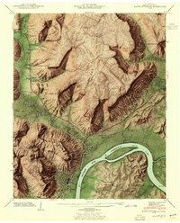
 1936 Shellmound1936 Print · USGSThe tristate borderlands of Georgia, Alabama, and Tennessee are captured here in the mid-1930s before the flooding of the Guntersville Reservoir. Genealogists can locate family landmarks like Stephens Cem, Burnett Chapel, and several local schools like Poplar Spring Sch.
 - 1936 Map of Bridgeport
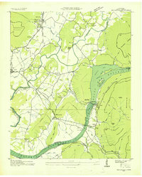
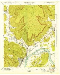
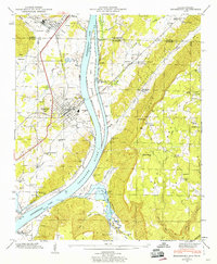
 1936 Bridgeport1936 Print · USGSBridgeport and the Tennessee River valley are seen here in the mid-1930s, just as the proposed Guntersville Reservoir was set to reshape the riverbank. Genealogists and historians can trace family locations near Richard City, locate the Island Creek Ferry, and find early sites like Mc Daniel Chapel and Concord Sch.
 - 1936 Map of Sequatchie
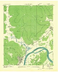
 1936 Sequatchie1936 Print · USGSMarion County is captured during its mid-1930s transformation as the TVA restructured the Tennessee River for hydroelectric power. Researchers can locate vanished landmarks like Rankin Ferry and the Marion County Home, or trace family roots at Old Union Cem and Wesley Chapel.
 - 1936 Map of South Pittsburg
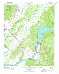
 1936 South Pittsburg1936 Print · USGSMarion County is seen here during a pivotal era of transformation as the Tennessee Valley Authority prepared for new reservoirs. Genealogists and historians can trace family-named sites like Gilliam Cem or Raulstontown, alongside the river-based commerce of the South Pittsburg Ferry.
 - 1942 Map of Sequatchie
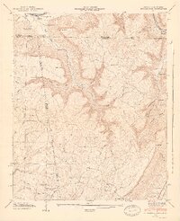
 1942 Sequatchie1942 Print · USGSMarion County during the early 1940s reveals a landscape defined by the Tennessee River and the rising Sequatchie Valley. Genealogists can locate family landmarks like Old Union Cem and Wesley Chapel or trace the old Rankin Ferry near Hales Bar Lake.2 unique versions available
 - 1942 Map of South Pittsburg, 1955 Print
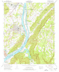
 1942 South Pittsburg1955 Print · USGSMarion County's river and mountain landscape comes alive in the 1940s as the Tennessee Valley Authority examines the region's development. Trace family roots at Raulston Cem, visit Jasper, or follow the St Louis and Chattanooga rail line through South Pittsburg.6 unique versions available
 - 1943 Map of South Pittsburg, 1946 Print
 1943 South Pittsburg1946 Print · USGSMarion County enters the mid-century as a vital river and rail corridor where the Cumberland Plateau meets the Tennessee River. Genealogists can trace family names at Raulston Cem, Chaudoin Cem, and rural schools like the Battle Creek Institute.2 unique versions available
 - 1943 Map of Sequatchie, 1946 Print
 1943 Sequatchie1946 Print · USGSThe Tennessee River valley in the early 1940s reveals a landscape being transformed by industrial power and major reservoir projects. Genealogists and historians can trace family locations through Old Union Cem, Killian Sch, and the Marion County Home.
 - 1945 Map of Shellmound
 1945 Shellmound1945 Print · USGSThe tri-state border of Tennessee, Alabama, and Georgia was a landscape of remote hollows and mountain gaps at the close of the 1940s. Genealogists can trace family roots through Murphy Cem and Free Home Ch, or locate vanished crossroads at Cole City and Stephensville.2 unique versions available
 - 1945 Map of Bridgeport
 1945 Bridgeport1945 Print · USGSBridgeport and the Tennessee River valley are captured in the mid-1940s as rail and river commerce shaped the Jackson County landscape. Local researchers can trace family sites like Kirkpatrick Cem, the Long Island Sch, and Moore Chapel.3 unique versions available
 - 1946 Map of Bridgeport
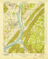 1946 Bridgeport1946 Print · USGSThe Tennessee River valley at Bridgeport is shown here in the mid-1940s, just after the creation of the reservoir. Genealogists can trace family landmarks like Kirkpatrick Cem, Ebenezer Ch, and the crossing at Reese Ferry.2 unique versions available
 - 1946 Map of Shellmound, 1947 Print
 1946 Shellmound1947 Print · USGSSand Mountain and the Tennessee River valley meet in this post-war tri-state survey of the Georgia, Alabama, and Tennessee borders. Researchers can trace rural life and ancestry through sites like State Line Cem, Shanty Town Ch, and the Shellmound Sta along the rail line.2 unique versions available
 - 1953 Map of Chattanooga
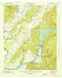
 1953 Chattanooga1953 Print · USGSSoutheast Tennessee in the early fifties shows a landscape reshaped by river management and rail power. Trace the rail lines of the Southern Ry through riverside towns or locate the preserved grounds of the Chickamauga and Chattanooga National Military Park.
 - 1955 Map of Rome
 1955 Rome1955 Print · USGSThe tri-state borderlands of Georgia, Alabama, and Tennessee appear in the mid-fifties as a landscape of ridge-and-valley industry and river navigation. Genealogists can trace family footprints near Chattanooga, the iron works of Gadsden, and textile towns like Trion or Summerville.
 - 1957 Map of Chattanooga, 1966 Print
 1957 Chattanooga1966 Print · USGSEast Tennessee in the mid-1960s shows a landscape of massive hydroelectric reservoirs and emerging industrial sites like the Atomic Energy Commission (Oak Ridge Area). Trace the rail networks of the Southern Ry through Chattanooga or locate family-named ridges across the Cumberland Plateau.3 unique versions available
 - 1958 Map of Rome, 1966 Print
 1958 Rome1966 Print · USGSNorthwest Georgia and neighboring Tennessee and Alabama are captured here in the late fifties, showcasing a landscape of high ridges and river valleys. Researchers can trace historic rail lines like the Seaboard Air Line RR and explore the bounds of Cloudland Canyon State Park or Fort Oglethorpe.3 unique versions available
 - 1959 Map of Chattanooga
 1959 Chattanooga1959 Print · USGSSoutheast Tennessee is shown here during a decade of industrial growth and hydroelectric development. Trace the regional rail networks of the Southern Ry and find landmark sites like Lookout Mountain, Fall Creek Falls State Park, and Chattanooga.
 - 1960 Map of Chattanooga
 1960 Chattanooga1960 Print · USGSSoutheast Tennessee and the southern Appalachians are shown here at the height of the river-management era. You can trace the valley rail lines and locate Lookout Mountain and the expansive waters of Chickamauga Reservoir.
 - 1961 Map of Rome
 1961 Rome1961 Print · USGSNorthwest Georgia and neighboring Tennessee and Alabama are shown here at a moment of significant mid-century growth. Researchers can trace the rail networks of the Central of Georgia or locate landmarks within Chickamauga and Chattanooga Nat Military Park.
 - 1963 Map of Rome
 1963 Rome1963 Print · USGSThe tri-state corner of Georgia, Alabama, and Tennessee is captured here during a period of massive reservoir expansion and post-war growth. Genealogists and historians can trace the rail corridors of the Southern Ry or locate landmarks like Fort Oglethorpe and Cloudland Canyon State Park.
 - 1964 Map of Chattanooga
 1964 Chattanooga1964 Print · USGSSoutheast Tennessee and the western Carolinas appear in the mid-sixties as a powerhouse of river-driven industry and mountain wilderness. Genealogists and historians can trace rail-town lineages along the Southern Ry or locate family landmarks near Watts Bar Lake and Tellico Plains.
 - 1970 Map of New Home, 1972 Print
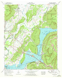
 1970 New Home1972 Print · USGSThe tri-state border of Georgia, Alabama, and Tennessee comes alive in the early seventies as the Tennessee River valley meets the coal-rich ridges. Genealogists and historians can trace family roots at Reeves Cem or Stephens Cem, and locate landmarks like Nickajack Cave and Cole City.2 unique versions available
 - 1970 Map of Sequatchie, 1972 Print
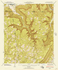
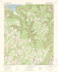
 1970 Sequatchie1972 Print · USGSThe Tennessee River valley south of Jasper is captured here in the early seventies, showing a landscape defined by major TVA reservoirs. Genealogists and researchers can locate family landmarks like Old Union Grove Cem or trace the site of the Hales Bar Dam.2 unique versions available
 - 1974 Map of Bridgeport, 1977 Print
 1974 Bridgeport1977 Print · USGSBridgeport and the Tennessee River valley are captured here in the mid-seventies as industrial sites and rural communities sit side-by-side. Trace local family roots at Richards Cem, locate the WIDOWS CREEK STEAM PLANT, or find old gathering spots like the Drive-in theater.2 unique versions available
 - 1979 Map of Chattanooga, 1980 Print
 1979 Chattanooga1980 Print · USGSSoutheast Tennessee in the late seventies reveals a landscape shaped by massive TVA river projects and the industrial strength of the Cumberland Plateau. Genealogists and historians can trace the rail-to-river network through L & N RR junctions, the University of the South, and the Volunteer Army Ammunition Plant.
Showing maps 1-25 of 28
Top cities near New Hope
- South Pittsburg historical maps
- Jasper historical maps
- Bridgeport historical maps
- Trenton historical maps
- Stevenson historical maps
- Whitwell historical maps
See more
Frequently asked questions
- What are the different types of historical maps available for New Hope?
- What is the oldest map of New Hope?
- Where can I purchase historical maps of New Hope for my home or office?
- Where can I download high-res historical maps of New Hope?
- Are there historical topographic maps available for New Hope?
- Is there historical aerial imagery available for New Hope?
- Where are historical maps of New Hope sourced from?