1930s Maps of Monteagle, Tennessee
Explore 4 historic maps of Monteagle from the 1930s. These maps offer a rare glimpse into what life looked like during the 1930s — showing old roads, neighborhoods, homes, and landmarks that have changed or disappeared over time.
Whether you're researching your family's past, planning a metal detecting trip, or studying how Monteagle's landscape evolved across the 1930s, these high-resolution maps are a powerful tool for exploring the history of this region.
- Focus on a specific era: All maps on this page are from the 1930s, giving you a focused view of this time period.
- See what’s changed: Compare century-old streets, trails, and buildings to today's modern landscape using overlays and satellite layers.
- Research with precision: Use these maps for genealogy, historical research, land use analysis, or educational projects.
- View, download, or print: Maps are fully viewable online in high resolution, and can be downloaded or printed for your own records.
Start exploring Monteagle's history through authentic maps from the 1930s. This is your window into the past.
Monteagle, TN maps
(4)- 1936 Map of Sewanee
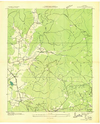
 1936 Sewanee1936 Print · USGSThe Cumberland Plateau and the Sewanee campus are captured here in the mid-1930s, showing a unique mountain landscape of academics and industry. Trace family roots at Cherry Cem or follow the path of the Cowan Tunnel and the Kelley Mine.
 - 1936 Map of Alto
 1936 Alto1936 Print · USGSThe Elk River valley at the Coffee and Franklin County line was a landscape of small settlements and river crossings in the mid-1930s. Genealogists can trace family roots through landmarks like Patton Sch, Bells Mill, and the Abernathy Cem.
 - 1936 Map of Burrow Cove
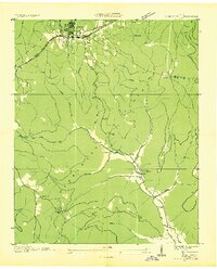
 1936 Burrow Cove1936 Print · USGSThe Cumberland Plateau of Tennessee is shown in the mid-1930s, featuring the deep hollows and high points of Grundy County. Researchers can trace historic landmarks like Wonder Cave, CCC Camp No 1476, and rural centers such as Piedmont and Summerfield.
 - 1936 Map of Monteagle
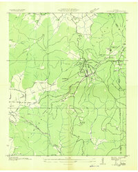
 1936 Monteagle1936 Print · USGSMonteagle and the surrounding Cumberland Plateau are captured here in the mid-1930s, showing the complex interaction between mountain travel and valley settlement. Researchers can trace historic schools and churches like Jumpoff Sch, St Johns Ch, and the high-altitude Monteagle Falls.
End of results
Showing maps 1-4 of 4
Top cities near Monteagle
- Manchester historical maps
- Winchester historical maps
- South Pittsburg historical maps
- Jasper historical maps
- Sewanee historical maps
- Decherd historical maps
See more
Top neighborhoods of Monteagle
Frequently asked questions
- What are the different types of historical maps available for Monteagle?
- What is the oldest map of Monteagle?
- Where can I purchase historical maps of Monteagle for my home or office?
- Where can I download high-res historical maps of Monteagle?
- Are there historical topographic maps available for Monteagle?
- Is there historical aerial imagery available for Monteagle?
- Where are historical maps of Monteagle sourced from?