1990s Maps of Shaver Town, Tennessee
Explore 1 historic maps of Shaver Town from the 1990s. These maps offer a rare glimpse into what life looked like during the 1990s — showing old roads, neighborhoods, homes, and landmarks that have changed or disappeared over time.
Whether you're researching your family's past, planning a metal detecting trip, or studying how Shaver Town's landscape evolved across the 1990s, these high-resolution maps are a powerful tool for exploring the history of this region.
- Focus on a specific era: All maps on this page are from the 1990s, giving you a focused view of this time period.
- See what’s changed: Compare century-old streets, trails, and buildings to today's modern landscape using overlays and satellite layers.
- Research with precision: Use these maps for genealogy, historical research, land use analysis, or educational projects.
- View, download, or print: Maps are fully viewable online in high resolution, and can be downloaded or printed for your own records.
Start exploring Shaver Town's history through authentic maps from the 1990s. This is your window into the past.
Shaver Town, TN maps
(1)- 1994 Map of New Middleton, 1997 Print
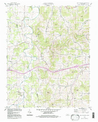 1994 New Middleton1997 Print · USGSThe Tennessee interior during the mid-1990s reveals a quiet landscape of agricultural valleys and family-named knobs along the Wilson Co Smith Co line. Local history enthusiasts can trace the rural communities of New Middleton and Grant alongside landmarks like Rawls Creek Ch and Bethlehem Cem.
End of results
Showing maps 1-1 of 1
Top cities near Shaver Town
- Lebanon historical maps
- Smithville historical maps
- Carthage historical maps
- Watertown historical maps
- South Carthage historical maps
- Gordonsville historical maps
See more
Frequently asked questions
- What are the different types of historical maps available for Shaver Town?
- What is the oldest map of Shaver Town?
- Where can I purchase historical maps of Shaver Town for my home or office?
- Where can I download high-res historical maps of Shaver Town?
- Are there historical topographic maps available for Shaver Town?
- Is there historical aerial imagery available for Shaver Town?
- Where are historical maps of Shaver Town sourced from?