1980s Maps of Williamson County, Tennessee
Explore 7 historic maps of Williamson County from the 1980s. These maps offer a rare glimpse into what life looked like during the 1980s — showing old roads, neighborhoods, homes, and landmarks that have changed or disappeared over time.
Whether you're researching your family's past, planning a metal detecting trip, or studying how Williamson County's landscape evolved across the 1980s, these high-resolution maps are a powerful tool for exploring the history of this region.
- Focus on a specific era: All maps on this page are from the 1980s, giving you a focused view of this time period.
- See what’s changed: Compare century-old streets, trails, and buildings to today's modern landscape using overlays and satellite layers.
- Research with precision: Use these maps for genealogy, historical research, land use analysis, or educational projects.
- View, download, or print: Maps are fully viewable online in high resolution, and can be downloaded or printed for your own records.
Start exploring Williamson County's history through authentic maps from the 1980s. This is your window into the past.
Williamson County, TN maps
(7)- 1981 Map of Franklin
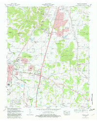 1981 Franklin1981 Print · USGSFranklin and Brentwood appear during a transformative era of growth south of Nashville in the early eighties. Family historians can trace numerous pioneer burial sites such as Primm Cem and McConnico Cem alongside landmarks like Ropers Knob.2 unique versions available
 - 1981 Map of Leipers Fork, 1982 Print
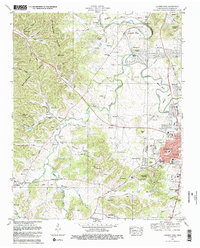 1981 Leipers Fork1982 Print · USGSFranklin and the rural stretches of the West Harpeth River valley are captured in the early eighties as residential growth began to meet historic farmsteads. Genealogists and local historians can trace legacy sites from the Indian Mound and Slave Cem to the Battle Ground Academy.3 unique versions available
 - 1982 Map of Bethesda, 1983 Print
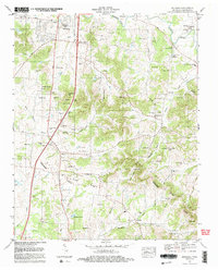 1982 Bethesda1983 Print · USGSThe rolling hills and hollows of Williamson County are captured here in the early 1980s, documenting a landscape of deep-rooted family farms and rural communities. Genealogists can trace hundreds of family names across Hardeman Cem, Peytonsville, and Bethesda.2 unique versions available
 - 1984 Map of Nashville, 1985 Print
 1984 Nashville1985 Print · USGSMiddle Tennessee in the mid-1980s reveals a region balancing urban expansion with its deep river-valley roots. Genealogists and historians can trace family locations near Old Hickory Lake, explore the grounds of Vanderbilt University, or locate ancestral sites like Greenwood Cem.
 - 1985 Map of Dickson
 1985 Dickson1985 Print · USGSMid-Tennessee in the mid-1980s was defined by the intersection of the Cumberland and Tennessee rivers and a massive network of wildlife refuges. Researchers can trace the Seaboard System rail lines connecting Waverly, Dickson, and White Bluff, or locate old landmarks near Fort Donelson National Military Park.
 - 1985 Map of Murfreesboro, 1986 Print
 1985 Murfreesboro1986 Print · USGSMiddle Tennessee in the mid-1980s shows a landscape of growing towns and deep-rooted rural outposts. Local researchers can trace old family lines near Bell Buckle, locate landmarks like Donnel Chapel, or explore the grounds of Henry Horton State Park and Hoovers Gap.
 - 1986 Map of Hohenwald
 1986 Hohenwald1986 Print · USGSThe Western Highland Rim of Tennessee comes into focus during the mid-eighties, showing the deep river valleys and high ridges of Lewis and Perry counties. Researchers can trace the path of the Natchez Trace Parkway or locate interior settlements like Chestnut Grove, Farmers Exchange, and Hustburg.3 unique versions available
End of results
Showing maps 1-7 of 7
Top cities of Williamson County
- Franklin historical maps
- Brentwood historical maps
- Nolensville historical maps
- Fairview historical maps
- Thompson's Station historical maps
Frequently asked questions
- What are the different types of historical maps available for Williamson County?
- What is the oldest map of Williamson County?
- Where can I purchase historical maps of Williamson County for my home or office?
- Where can I download high-res historical maps of Williamson County?
- Are there historical topographic maps available for Williamson County?
- Is there historical aerial imagery available for Williamson County?
- Where are historical maps of Williamson County sourced from?