1990s Maps of Williamson County, Tennessee
Explore 5 historic maps of Williamson County from the 1990s. These maps offer a rare glimpse into what life looked like during the 1990s — showing old roads, neighborhoods, homes, and landmarks that have changed or disappeared over time.
Whether you're researching your family's past, planning a metal detecting trip, or studying how Williamson County's landscape evolved across the 1990s, these high-resolution maps are a powerful tool for exploring the history of this region.
- Focus on a specific era: All maps on this page are from the 1990s, giving you a focused view of this time period.
- See what’s changed: Compare century-old streets, trails, and buildings to today's modern landscape using overlays and satellite layers.
- Research with precision: Use these maps for genealogy, historical research, land use analysis, or educational projects.
- View, download, or print: Maps are fully viewable online in high resolution, and can be downloaded or printed for your own records.
Start exploring Williamson County's history through authentic maps from the 1990s. This is your window into the past.
Williamson County, TN maps
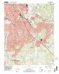
(5)- 1997 Map of Franklin, 2002 Print
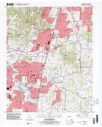 1997 Franklin2002 Print · USGSFranklin and Brentwood underwent significant growth in the late nineties as residential estates expanded across the Tennessee hills. Genealogists can trace family heritage through numerous burial grounds including Owen Cem, Crockett Cem, and the Confederate Cem.
 - 1997 Map of Oak Hill, 2002 Print
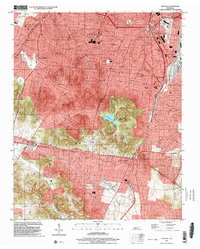 1997 Oak Hill2002 Print · USGSSouth of Nashville in the late nineties, these residential enclaves expanded toward the Williamson County line. Researchers can trace the development of Belle Meade and Oak Hill, or locate local landmarks like Radnor Lake and the Governors Mansion.
 - 1997 Map of Bellevue, 2002 Print
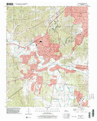 1997 Bellevue2002 Print · USGSGreater Nashville was rapidly expanding toward the Harpeth River valley in the late nineties, blending suburban growth with older river-bend settlements. Trace local landmarks like the Bellevue High Sch, Warner Park, and the winding Harpeth River.
 - 1998 Map of Smyrna, 1999 Print
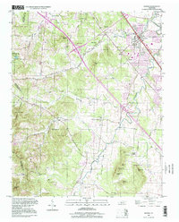 1998 Smyrna1999 Print · USGSRutherford and Davidson counties are mapped here in the late nineties as regional growth begins to reshape the landscape. Genealogists and researchers can trace local family lineages through numerous small burial sites like Dewitt Smith Jobe Cem, Sanford Cem, and the Sam Davis Home Cem.
 - 1999 Map of Antioch, 2002 Print
 1999 Antioch2002 Print · USGSThe Antioch and south Nashville area comes into focus at the end of the millennium as suburban development spreads toward the Williamson County line. Trace family landmarks and community anchors from Whittset Cem to schools like Binkley Sch and Turner Sch.
End of results
Showing maps 1-5 of 5
Top cities of Williamson County
- Franklin historical maps
- Brentwood historical maps
- Nolensville historical maps
- Fairview historical maps
- Thompson's Station historical maps
Frequently asked questions
- What are the different types of historical maps available for Williamson County?
- What is the oldest map of Williamson County?
- Where can I purchase historical maps of Williamson County for my home or office?
- Where can I download high-res historical maps of Williamson County?
- Are there historical topographic maps available for Williamson County?
- Is there historical aerial imagery available for Williamson County?
- Where are historical maps of Williamson County sourced from?