1960s Maps of Anderson County, Texas
Explore 6 historic maps of Anderson County from the 1960s. These maps offer a rare glimpse into what life looked like during the 1960s — showing old roads, neighborhoods, homes, and landmarks that have changed or disappeared over time.
Whether you're researching your family's past, planning a metal detecting trip, or studying how Anderson County's landscape evolved across the 1960s, these high-resolution maps are a powerful tool for exploring the history of this region.
- Focus on a specific era: All maps on this page are from the 1960s, giving you a focused view of this time period.
- See what’s changed: Compare century-old streets, trails, and buildings to today's modern landscape using overlays and satellite layers.
- Research with precision: Use these maps for genealogy, historical research, land use analysis, or educational projects.
- View, download, or print: Maps are fully viewable online in high resolution, and can be downloaded or printed for your own records.
Start exploring Anderson County's history through authentic maps from the 1960s. This is your window into the past.
Anderson County, TX maps
(6)- 1960 Map of Creslenn Ranch, 1961 Print
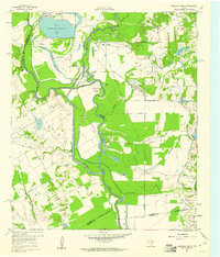 1960 Creslenn Ranch1961 Print · USGSThe Trinity River bottoms and the Cayuga oil country are captured here at the start of the 1960s. Genealogists and local historians can trace the Princeton Cem, the remote Creslenn Ranch, and landmarks like Hall Lake and Trinidad.3 unique versions available
 - 1960 Map of Roustabout Camp, 1961 Print
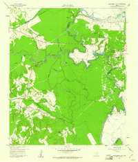 1960 Roustabout Camp1961 Print · USGSThe Trinity River bottoms at the Freestone and Anderson county line show a busy mid-century landscape of energy production and river-fed agriculture. Genealogists and historians can trace industrial camps like Roustabout Camp and Amerada Camp or local landmarks such as Harp Ch.4 unique versions available
 - 1961 Map of Young, 1962 Print
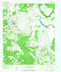
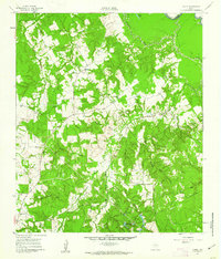 1961 Young1962 Print · USGSFreestone County's rural landscape is captured here in the early sixties, showing the intersection of local agriculture and the petroleum industry. Researchers can find generational landmarks like Rehoboth Cem, Hodge Lodge, and the Stewards Mill Oil Field.3 unique versions available
 - 1964 Map of Long Lake, 1967 Print
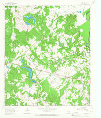
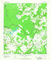 1964 Long Lake1967 Print · USGSAnderson County during the mid-1960s was a landscape defined by the winding Trinity River and a burgeoning energy sector. Genealogists and local historians can pinpoint Mt Pilgrim Ch, the Green Bay High Sch, and the rail infrastructure of the Missouri Pacific.3 unique versions available
 - 1964 Map of Oakwood, 1967 Print
 1964 Oakwood1967 Print · USGSOakwood and the rural fringes of Leon County are captured here in the mid-1960s, centered on the Missouri Pacific rail corridor. Researchers can trace family roots through landmarks like Dunbar High Sch, Mount Pisgah Cem, and the Sand Flats settlement.
 - 1964 Map of Butler, 1967 Print
 1964 Butler1967 Print · USGSThe rural communities of Freestone County are captured here in the mid-1960s, just as the regional landscape was being reshaped by large ponds and reservoirs. You can trace family histories through numerous landmarks like Butler High School, the Maze Cemetery, and the Daniel Memorial WT Childrens Home.3 unique versions available
End of results
Showing maps 1-6 of 6
Top cities of Anderson County
Frequently asked questions
- What are the different types of historical maps available for Anderson County?
- What is the oldest map of Anderson County?
- Where can I purchase historical maps of Anderson County for my home or office?
- Where can I download high-res historical maps of Anderson County?
- Are there historical topographic maps available for Anderson County?
- Is there historical aerial imagery available for Anderson County?
- Where are historical maps of Anderson County sourced from?