1960s Maps of Bellville, Texas
Explore 2 historic maps of Bellville from the 1960s. These maps offer a rare glimpse into what life looked like during the 1960s — showing old roads, neighborhoods, homes, and landmarks that have changed or disappeared over time.
Whether you're researching your family's past, planning a metal detecting trip, or studying how Bellville's landscape evolved across the 1960s, these high-resolution maps are a powerful tool for exploring the history of this region.
- Focus on a specific era: All maps on this page are from the 1960s, giving you a focused view of this time period.
- See what’s changed: Compare century-old streets, trails, and buildings to today's modern landscape using overlays and satellite layers.
- Research with precision: Use these maps for genealogy, historical research, land use analysis, or educational projects.
- View, download, or print: Maps are fully viewable online in high resolution, and can be downloaded or printed for your own records.
Start exploring Bellville's history through authentic maps from the 1960s. This is your window into the past.
Bellville, TX maps
(2)- 1961 Map of Burleigh, 1962 Print
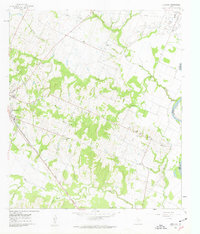 1961 Burleigh1962 Print · USGSThe Austin County countryside in the early sixties is captured here, centered on the community of Burleigh. Researchers can trace family sites like Coshatte Cem, the Coshatte Agricultural Society Hall, and several local rural schools.2 unique versions available
 - 1963 Map of Bellville, 1982 Print
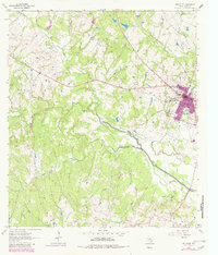 1963 Bellville1982 Print · USGSBellville and its surrounding Austin County prairies are captured here in the early sixties as the town expanded near the Atchison Topeka and Santa Fe tracks. Trace old family burial sites like Wochement Cem and the industrial layout of the Millheim Gas Field.
End of results
Showing maps 1-2 of 2
Top cities near Bellville
- Brenham historical maps
- Sealy historical maps
- Hempstead historical maps
- Pine Island historical maps
- San Felipe historical maps
- Industry historical maps
See more
Frequently asked questions
- What are the different types of historical maps available for Bellville?
- What is the oldest map of Bellville?
- Where can I purchase historical maps of Bellville for my home or office?
- Where can I download high-res historical maps of Bellville?
- Are there historical topographic maps available for Bellville?
- Is there historical aerial imagery available for Bellville?
- Where are historical maps of Bellville sourced from?