1960s Maps of Sealy, Texas
Explore 4 historic maps of Sealy from the 1960s. These maps offer a rare glimpse into what life looked like during the 1960s — showing old roads, neighborhoods, homes, and landmarks that have changed or disappeared over time.
Whether you're researching your family's past, planning a metal detecting trip, or studying how Sealy's landscape evolved across the 1960s, these high-resolution maps are a powerful tool for exploring the history of this region.
- Focus on a specific era: All maps on this page are from the 1960s, giving you a focused view of this time period.
- See what’s changed: Compare century-old streets, trails, and buildings to today's modern landscape using overlays and satellite layers.
- Research with precision: Use these maps for genealogy, historical research, land use analysis, or educational projects.
- View, download, or print: Maps are fully viewable online in high resolution, and can be downloaded or printed for your own records.
Start exploring Sealy's history through authentic maps from the 1960s. This is your window into the past.
Sealy, TX maps
(4)- 1960 Map of Wallis, 1961 Print
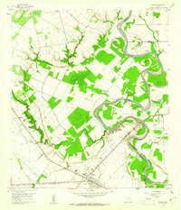 1960 Wallis1961 Print · USGSThe Brazos River bottomlands in the early sixties reveal a landscape shaped by rail junctions and small farming communities. Genealogists can trace family roots through sites like Hartville Cem, Mount Olive Ch, and the intersection of two major railroads in Wallis.3 unique versions available
 - 1960 Map of San Felipe, 1961 Print
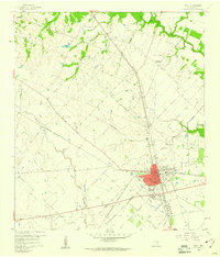
 1960 San Felipe1961 Print · USGSThe Brazos River valley in the early 1960s reveals a landscape of colonial heritage and oil-era industry. Genealogists can trace family names through numerous rural sites like Rosses Cem, Wesley Chapel, and the community of Frydek.5 unique versions available
 - 1960 Map of Rexville, 1961 Print
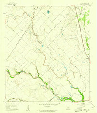 1960 Rexville1961 Print · USGSThe rural borderlands of Austin and Wharton Counties are captured here in the early sixties as the oil and gas industry matured. Trace old rail lines like the Gulf Colorado and Santa Fe through Rexville or locate the Chesterville Oil Field.2 unique versions available
 - 1960 Map of Sealy, 1961 Print
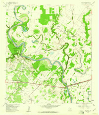
 1960 Sealy1961 Print · USGSSealy served as a vital rail crossroads in the early sixties, where major lines met amidst the rolling ranch land and creek bottoms. Local researchers can locate Macedonia Cem, the Hospital, and the path of the Old Railroad Grade.3 unique versions available
End of results
Showing maps 1-4 of 4
Top cities near Sealy
- Rosenberg historical maps
- Brookshire historical maps
- Bellville historical maps
- Eagle Lake historical maps
- East Bernard historical maps
- Wallis historical maps
See more
Frequently asked questions
- What are the different types of historical maps available for Sealy?
- What is the oldest map of Sealy?
- Where can I purchase historical maps of Sealy for my home or office?
- Where can I download high-res historical maps of Sealy?
- Are there historical topographic maps available for Sealy?
- Is there historical aerial imagery available for Sealy?
- Where are historical maps of Sealy sourced from?