1980s Maps of San Antonio, Texas
Explore 4 historic maps of San Antonio from the 1980s. These maps offer a rare glimpse into what life looked like during the 1980s — showing old roads, neighborhoods, homes, and landmarks that have changed or disappeared over time.
Whether you're researching your family's past, planning a metal detecting trip, or studying how San Antonio's landscape evolved across the 1980s, these high-resolution maps are a powerful tool for exploring the history of this region.
- Focus on a specific era: All maps on this page are from the 1980s, giving you a focused view of this time period.
- See what’s changed: Compare century-old streets, trails, and buildings to today's modern landscape using overlays and satellite layers.
- Research with precision: Use these maps for genealogy, historical research, land use analysis, or educational projects.
- View, download, or print: Maps are fully viewable online in high resolution, and can be downloaded or printed for your own records.
Start exploring San Antonio's history through authentic maps from the 1980s. This is your window into the past.
San Antonio, TX maps
(4)- 1985 Map of New Braunfels
 1985 New Braunfels1985 Print · USGSThe Texas Hill Country meets the growing San Antonio suburbs in the mid-1980s, showing a landscape of river-fed towns and military grounds. Trace family roots in historic Gruene or Boerne, and locate landmarks like Canyon Lake and Randolph Air Force Base.
 - 1985 Map of San Antonio
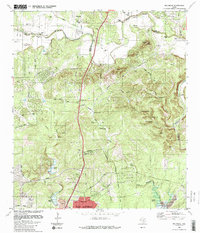
 1985 San Antonio1985 Print · USGSSan Antonio and its surrounding hill country are captured in the mid-eighties during a period of significant suburban and military expansion. Genealogists and historians can trace the footprint of Kelly Air Force Base, old rail lines like the Missouri-Kansas-Texas, and smaller communities like Saspamco or Zuehl.3 unique versions available
 - 1988 Map of Bat Cave
 1988 Bat Cave1988 Print · USGSThe Comal and Bexar county line area is captured here in the late eighties, showing a landscape defined by its famous caverns and limestone creeks. Genealogists can locate family burial sites like Weilbacher Cem and landmarks such as Bat Cave or Bracken Ch.
 - 1988 Map of Bulverde
 1988 Bulverde1988 Print · USGSTexas Hill Country life at the edge of Comal County comes into focus in the late eighties as ranching traditions meet modern expansion. Genealogists can trace family heritage through numerous burial sites like Schlather Cem and Weidner Cem or locate landmarks like Vogels Peak.
End of results
Showing maps 1-4 of 4
Top cities near San Antonio
- Schertz historical maps
- Universal City historical maps
- Converse historical maps
- Live Oak historical maps
- Leon Valley historical maps
- Selma historical maps
See more
Top neighborhoods of San Antonio
- Southton historical maps
- Boldtville historical maps
- Cassin historical maps
- Hilltop historical maps
- Westover Hills historical maps
- Stone Oak historical maps
See more
Frequently asked questions
- What are the different types of historical maps available for San Antonio?
- What is the oldest map of San Antonio?
- Where can I purchase historical maps of San Antonio for my home or office?
- Where can I download high-res historical maps of San Antonio?
- Are there historical topographic maps available for San Antonio?
- Is there historical aerial imagery available for San Antonio?
- Where are historical maps of San Antonio sourced from?