1940s Maps of Angleton, Texas
Explore 3 historic maps of Angleton from the 1940s. These maps offer a rare glimpse into what life looked like during the 1940s — showing old roads, neighborhoods, homes, and landmarks that have changed or disappeared over time.
Whether you're researching your family's past, planning a metal detecting trip, or studying how Angleton's landscape evolved across the 1940s, these high-resolution maps are a powerful tool for exploring the history of this region.
- Focus on a specific era: All maps on this page are from the 1940s, giving you a focused view of this time period.
- See what’s changed: Compare century-old streets, trails, and buildings to today's modern landscape using overlays and satellite layers.
- Research with precision: Use these maps for genealogy, historical research, land use analysis, or educational projects.
- View, download, or print: Maps are fully viewable online in high resolution, and can be downloaded or printed for your own records.
Start exploring Angleton's history through authentic maps from the 1940s. This is your window into the past.
Angleton, TX maps
(3)- 1943 Map of Rosharon
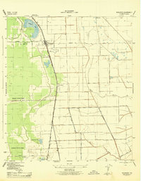 1943 Rosharon1943 Print · USGSBrazoria County agricultural and institutional life comes into focus during the early 1940s, centered on the rail corridor through Rosharon. Local researchers can trace old burial sites at Pilgrim Cem and Daughters Cem or locate the sprawling Ramsey State Farm.2 unique versions available
 - 1943 Map of Angleton, 1958 Print
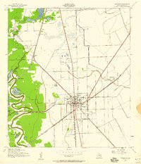 1943 Angleton1958 Print · USGSAngleton and the surrounding Brazoria County prairies are shown here during the early 1940s, when the regional economy centered on the railroad and riverside farming. Researchers can trace historic family landmarks such as Bearle Chapel, Revelation Cem, and the Texas Agricultural Experimental Station.
 - 1943 Map of Snipe, 1959 Print
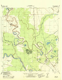 1943 Snipe1959 Print · USGSCoastal Brazoria County was undergoing a mid-century transformation as suburban development met traditional river bottomlands. Researchers can trace the early street grid of Lake Jackson, the sprawling Retrieve State Farm, and local landmarks like Trueona Ch and Wharton Cem.2 unique versions available
End of results
Showing maps 1-3 of 3
Top cities near Angleton
- Lake Jackson historical maps
- Alvin historical maps
- Iowa Colony historical maps
- Freeport historical maps
- Clute historical maps
- West Columbia historical maps
See more
Top neighborhoods of Angleton
Frequently asked questions
- What are the different types of historical maps available for Angleton?
- What is the oldest map of Angleton?
- Where can I purchase historical maps of Angleton for my home or office?
- Where can I download high-res historical maps of Angleton?
- Are there historical topographic maps available for Angleton?
- Is there historical aerial imagery available for Angleton?
- Where are historical maps of Angleton sourced from?