1960s Maps of Angleton, Texas
Explore 3 historic maps of Angleton from the 1960s. These maps offer a rare glimpse into what life looked like during the 1960s — showing old roads, neighborhoods, homes, and landmarks that have changed or disappeared over time.
Whether you're researching your family's past, planning a metal detecting trip, or studying how Angleton's landscape evolved across the 1960s, these high-resolution maps are a powerful tool for exploring the history of this region.
- Focus on a specific era: All maps on this page are from the 1960s, giving you a focused view of this time period.
- See what’s changed: Compare century-old streets, trails, and buildings to today's modern landscape using overlays and satellite layers.
- Research with precision: Use these maps for genealogy, historical research, land use analysis, or educational projects.
- View, download, or print: Maps are fully viewable online in high resolution, and can be downloaded or printed for your own records.
Start exploring Angleton's history through authentic maps from the 1960s. This is your window into the past.
Angleton, TX maps
(3)- 1963 Map of Angleton, 1966 Print
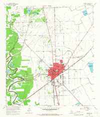 1963 Angleton1966 Print · USGSBrazoria County undergoes significant development in the early sixties as the oil industry and regional rail lines reshape the prairie. Researchers can trace family history at Burrel Chapel Cem or locate the former Texas Agricultural Experimental Station and Bailes Airfield.3 unique versions available
 - 1963 Map of Rosharon, 1966 Print
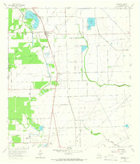 1963 Rosharon1966 Print · USGSBrazoria County in the early 1960s was a landscape where old Texas plantations and newer oil fields converged along the Missouri Pacific railroad. Genealogists can trace family roots at Daughters Cem and Pilgrim Cem, or locate the historic Chenango Plantation.2 unique versions available
 - 1963 Map of Lake Jackson, 1966 Print
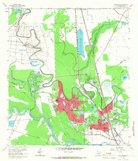 1963 Lake Jackson1966 Print · USGSIn the early 1960s, the Brazos River bottomlands saw the rapid growth of Lake Jackson and Clute amidst established correctional units. Researchers can trace local development through Lake Jackson, Lake Jackson Farms, and neighborhood landmarks like St Michaels Ch.4 unique versions available
End of results
Showing maps 1-3 of 3
Top cities near Angleton
- Lake Jackson historical maps
- Alvin historical maps
- Iowa Colony historical maps
- Freeport historical maps
- Clute historical maps
- West Columbia historical maps
See more
Top neighborhoods of Angleton
Frequently asked questions
- What are the different types of historical maps available for Angleton?
- What is the oldest map of Angleton?
- Where can I purchase historical maps of Angleton for my home or office?
- Where can I download high-res historical maps of Angleton?
- Are there historical topographic maps available for Angleton?
- Is there historical aerial imagery available for Angleton?
- Where are historical maps of Angleton sourced from?