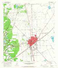
1963 Map of Angleton
USGS Topo · Published 1966About this map
The Brazoria County seat of Angleton serves as the hub of this 1963 survey, illustrating a coastal Texas landscape defined by both petroleum extraction and agricultural research. The Missouri Pacific railroad cuts through the center of town, connecting it to smaller outlying points like Anchor and Van Pelt. Significant land use is dedicated to the Texas Agricultural Experimental Station and a series of educational facilities, including Marshall Sch and Central Sch.
Find a feature on this map
45 named features on this map. Tap any name to fly to it.
Don’t see what you’re looking for? This feature index may not catch every label — zoom into the map to look around manually.
Map Details
Editions of this 1963 Angleton Map
3 editions found
Other maps of this area

1943 · Oyster Creek
USGS Topo · 1:31,680

1943 · Rosharon
USGS Topo · 1:31,680

1943 · Danbury
USGS Topo · 1:31,680

1943 · Angleton
USGS Topo · 1:24,000

1943 · Chocolate Bayou
USGS Topo · 1:24,000

1943 · Snipe
USGS Topo · 1:31,680

1950 · Houston
USGS Topo · 1:250,000

1952 · East Columbia
USGS Topo · 1:24,000

1952 · Brazoria
USGS Topo · 1:24,000

1953 · Otey
USGS Topo · 1:24,000