
1943 Map of Rosharon
USGS Topo · Published 1943About this map
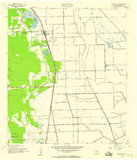
The Missouri Pacific railroad corridor serves as the primary axis for this wartime survey of Brazoria County, linking the small communities of Rosharon and Bonney. The landscape is largely defined by the agricultural operations of the Ramsey State Farm, which occupies a significant portion of the western territory. This institutional presence is complemented by a network of localized rural hubs, evidenced by scattered educational and spiritual landmarks such as China Grove Sch and Zion Ch.
Find a feature on this map
21 named features on this map. Tap any name to fly to it.
Don’t see what you’re looking for? This feature index may not catch every label — zoom into the map to look around manually.
Map Details
Editions of this 1943 Rosharon Map
2 editions found
Other maps of this area

1943 · Danbury
USGS Topo · 1:31,680

1943 · Juliff
USGS Topo · 1:31,680

1943 · Angleton
USGS Topo · 1:24,000

1943 · Chocolate Bayou
USGS Topo · 1:24,000

1950 · Houston
USGS Topo · 1:250,000

1952 · East Columbia
USGS Topo · 1:24,000

1953 · Otey
USGS Topo · 1:24,000

1953 · Thompsons
USGS Topo · 1:24,000
1956 · Manvel
USGS Topo · 1:24,000

1956 · Houston
USGS Topo · 1:250,000