
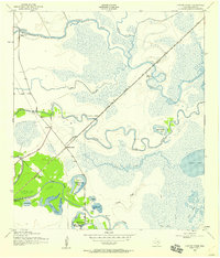
1943 Map of Oyster Creek
USGS Topo · Published 1943About this map
Bastrop Beach and the winding course of Bastrop Bayou define this coastal Texas landscape during the early 1940s. The region is characterized by an intricate network of waterways, where Big Slough and Little Slough cut through low-lying ridges, eventually feeding into the expansive Salt Lake. Inland, the Missouri Pacific railroad serves as the primary transportation spine, passing through the settlement of Mims and tracing the edge of Stratton Ridge. Local life is anchored by family landmarks and community centers such as Bethel Ch, Evergreen Ch, and the Hudgens Cem. This survey, conducted by the Tennessee Valley Authority for the War Department, captures a transitional environment of salt marshes and sloughs just before mid-century developments altered the Brazoria County coastline. Unique features like Square Island Lake and the curiously named Slop Bowl highlight the specific topography of this river-and-bayou system.
Find a feature on this map
32 named features on this map. Tap any name to fly to it.
Don’t see what you’re looking for? This feature index may not catch every label — zoom into the map to look around manually.
Map Details
Editions of this 1943 Oyster Creek Map
2 editions found
Other maps of this area

1943 · Jones Creek
USGS Topo · 1:31,680

1943 · Danbury
USGS Topo · 1:31,680

1943 · Freeport
USGS Topo · 1:31,680

1943 · Angleton
USGS Topo · 1:24,000

1943 · Christmas Point
USGS Topo · 1:24,000

1943 · Chocolate Bay
USGS Topo · 1:24,000

1943 · Snipe
USGS Topo · 1:31,680

1950 · Houston
USGS Topo · 1:250,000

1951 · Bay City
USGS Topo · 1:250,000

1956 · Houston
USGS Topo · 1:250,000