1920s Maps of Manvel, Texas
Explore 2 historic maps of Manvel from the 1920s. These maps offer a rare glimpse into what life looked like during the 1920s — showing old roads, neighborhoods, homes, and landmarks that have changed or disappeared over time.
Whether you're researching your family's past, planning a metal detecting trip, or studying how Manvel's landscape evolved across the 1920s, these high-resolution maps are a powerful tool for exploring the history of this region.
- Focus on a specific era: All maps on this page are from the 1920s, giving you a focused view of this time period.
- See what’s changed: Compare century-old streets, trails, and buildings to today's modern landscape using overlays and satellite layers.
- Research with precision: Use these maps for genealogy, historical research, land use analysis, or educational projects.
- View, download, or print: Maps are fully viewable online in high resolution, and can be downloaded or printed for your own records.
Start exploring Manvel's history through authentic maps from the 1920s. This is your window into the past.
Manvel, TX maps
(2)- 1920 Map of Mykawa
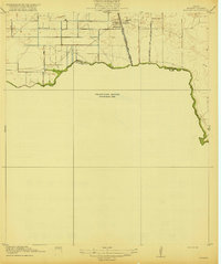 1920 Mykawa1920 Print · USGSIn the early twentieth century, the Gulf Coast prairie around Mykawa was a landscape of emerging rail stops and rural schoolhouses. Genealogists and historians can trace the early paths of the Houston and Alvin Road and the Minnetex School.3 unique versions available
 - 1920 Map of Almeda
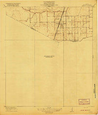 1920 Almeda1920 Print · USGSHarris County prairie land is captured here during the First World War era, showing a landscape defined by rail and water. Genealogists and researchers can trace the early footprint of Almeda and the path of the International and Great Northern railroad.2 unique versions available
End of results
Showing maps 1-2 of 2
Top cities near Manvel
- Houston historical maps
- Pasadena historical maps
- Pearland historical maps
- League City historical maps
- Sugar Land historical maps
- Missouri City historical maps
See more
Frequently asked questions
- What are the different types of historical maps available for Manvel?
- What is the oldest map of Manvel?
- Where can I purchase historical maps of Manvel for my home or office?
- Where can I download high-res historical maps of Manvel?
- Are there historical topographic maps available for Manvel?
- Is there historical aerial imagery available for Manvel?
- Where are historical maps of Manvel sourced from?