1910s Maps of Brazos County, Texas
Explore 3 historic maps of Brazos County from the 1910s. These maps offer a rare glimpse into what life looked like during the 1910s — showing old roads, neighborhoods, homes, and landmarks that have changed or disappeared over time.
Whether you're researching your family's past, planning a metal detecting trip, or studying how Brazos County's landscape evolved across the 1910s, these high-resolution maps are a powerful tool for exploring the history of this region.
- Focus on a specific era: All maps on this page are from the 1910s, giving you a focused view of this time period.
- See what’s changed: Compare century-old streets, trails, and buildings to today's modern landscape using overlays and satellite layers.
- Research with precision: Use these maps for genealogy, historical research, land use analysis, or educational projects.
- View, download, or print: Maps are fully viewable online in high resolution, and can be downloaded or printed for your own records.
Start exploring Brazos County's history through authentic maps from the 1910s. This is your window into the past.
Brazos County, TX maps
(3)- 1913 Map of Millican
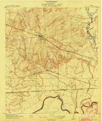 1913 Millican1913 Print · USGSBrazos County at the beginning of the twentieth century was a critical rail junction defined by large-scale valley farming and the winding river border. Researchers can trace historic riverfront operations and rail stops including Millican, Hidalgo Falls, and the Steele Farm.3 unique versions available
 - 1914 Map of Gay Hill
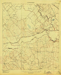 1914 Gay Hill1914 Print · USGSThe Brazos River valley in the early twentieth century shows a thriving rail-and-farm economy across three counties. Genealogists can trace family landmarks and rural school sites like Wiedes Store, Old Gay Hill, and the Allseeing Eye School.2 unique versions available
 - 1914 Map of Navasota
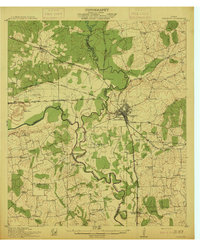 1914 Navasota1914 Print · USGSBefore the modernization of the Brazos valley, this 1910s era survey captures the thriving rail-and-river economy of Grimes and Washington counties. Genealogists can trace early homesteads and community hubs like Wilsons Gin, Prairie Church, and Grange Hall School.2 unique versions available
End of results
Showing maps 1-3 of 3
Top cities of Brazos County
- College Station historical maps
- Bryan historical maps
- Millican historical maps
- Kurten historical maps
- Wixon Valley historical maps
Frequently asked questions
- What are the different types of historical maps available for Brazos County?
- What is the oldest map of Brazos County?
- Where can I purchase historical maps of Brazos County for my home or office?
- Where can I download high-res historical maps of Brazos County?
- Are there historical topographic maps available for Brazos County?
- Is there historical aerial imagery available for Brazos County?
- Where are historical maps of Brazos County sourced from?