1960s Maps of Brazos County, Texas
Explore 11 historic maps of Brazos County from the 1960s. These maps offer a rare glimpse into what life looked like during the 1960s — showing old roads, neighborhoods, homes, and landmarks that have changed or disappeared over time.
Whether you're researching your family's past, planning a metal detecting trip, or studying how Brazos County's landscape evolved across the 1960s, these high-resolution maps are a powerful tool for exploring the history of this region.
- Focus on a specific era: All maps on this page are from the 1960s, giving you a focused view of this time period.
- See what’s changed: Compare century-old streets, trails, and buildings to today's modern landscape using overlays and satellite layers.
- Research with precision: Use these maps for genealogy, historical research, land use analysis, or educational projects.
- View, download, or print: Maps are fully viewable online in high resolution, and can be downloaded or printed for your own records.
Start exploring Brazos County's history through authentic maps from the 1960s. This is your window into the past.
Brazos County, TX maps
(11)- 1961 Map of Mumford, 1964 Print
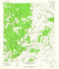
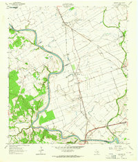 1961 Mumford1964 Print · USGSThe Brazos River valley in the early sixties is a landscape of rural junctions and historic outposts at the meeting point of four counties. Researchers can locate the Fort Tenoxtitlan (Site), the rail sidings at Mudville, and local landmarks like Smith Sch.3 unique versions available
 - 1961 Map of Wellborn, 1965 Print
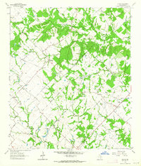
 1961 Wellborn1965 Print · USGSBrazos County during the early 1960s showcases the growing footprint of Texas A & M University alongside traditional rail-side settlements. Genealogists and historians can trace rural life through landmarks like Salem Ch, the College Station Cem, and old stops along the Missouri Pacific railroad.4 unique versions available
 - 1962 Map of Edge, 1964 Print
 1962 Edge1964 Print · USGSRobertson and Brazos counties in the early sixties remain a landscape of small rural settlements and family cemeteries. Genealogy researchers can trace local roots at Edge, Shiloh Ch, and the historic Kings Highway that cuts through the region.2 unique versions available
 - 1962 Map of Wheelock, 1964 Print
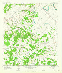
 1962 Wheelock1964 Print · USGSIn the early 1960s, the Robertson and Brazos county line was a landscape of rural schoolhouse-era churches and family cemeteries. Researchers can find ancestral sites at Wheelock Cem, Cavit Cem, and the historic Henry Prairie Ch.3 unique versions available
 - 1962 Map of Tunis, 1964 Print
 1962 Tunis1964 Print · USGSBurleson County in the early sixties reveals a landscape of river-bottom farms and small rail-stop communities. Genealogists and historians can trace family roots through sites like Salem Cem, the New Jerusalem Ch, and the settlement of Cooks Point.2 unique versions available
 - 1962 Map of Chances Store, 1964 Print
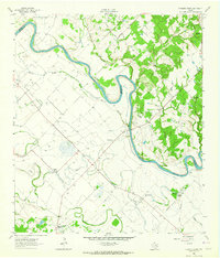 1962 Chances Store1964 Print · USGSBrazos and Burleson counties are shown here in the early sixties as the Brazos River meanders through a landscape of rural stores and family farms. Researchers can locate the Newsome Cemetery, Jones High School, and community landmarks like Chances Store and Grant.5 unique versions available
 - 1962 Map of Bryan East, 1964 Print
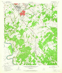
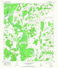
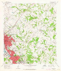 1962 Bryan East1964 Print · USGSThe Bryan and College Station area is captured during a period of significant mid-century growth. Genealogists and local historians can trace family-named landmarks such as Kizer Cem, explore the rural settlement at Boonville, and locate early schools like Fannin Sch.5 unique versions available
 - 1962 Map of Bryan West, 1965 Print
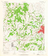 1962 Bryan West1965 Print · USGSBrazos County in the early sixties shows the westward expansion of Bryan toward the Little Brazos River. Trace family roots at Rest-Ever Memorial Cem or explore the rail-side life in Smetana and Benchley.4 unique versions available
 - 1963 Map of Dunn Creek, 1964 Print
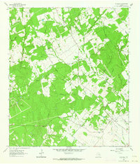
 1963 Dunn Creek1964 Print · USGSRobertson and Brazos counties in the early sixties reveal a landscape of creek-side settlements and early frontier history. Researchers can trace family roots at Walker Settlement Cem and locate the historic Dunns Fort (Site) or the railroad stop at Alexander.2 unique versions available
 - 1963 Map of Kurten, 1964 Print
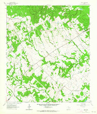
 1963 Kurten1964 Print · USGSBrazos County is captured in the early sixties as a region of tight-knit rural communities and family landholdings. Researchers can locate numerous family burial sites and country churches, including Schultze Cem, Cottonwood Ch, and the settlement of Kurten.2 unique versions available
 - 1965 Map of Canary, 1968 Print
 1965 Canary1968 Print · USGSMadison and Leon counties are mapped here in the mid-sixties, showing a landscape of river bottoms and rural landings. Genealogists can locate family landmarks like Plainview Cem, Manning Ch, and the crossing at Bundy Crossing.2 unique versions available
End of results
Showing maps 1-11 of 11
Top cities of Brazos County
- College Station historical maps
- Bryan historical maps
- Millican historical maps
- Kurten historical maps
- Wixon Valley historical maps
Frequently asked questions
- What are the different types of historical maps available for Brazos County?
- What is the oldest map of Brazos County?
- Where can I purchase historical maps of Brazos County for my home or office?
- Where can I download high-res historical maps of Brazos County?
- Are there historical topographic maps available for Brazos County?
- Is there historical aerial imagery available for Brazos County?
- Where are historical maps of Brazos County sourced from?