1950s Maps of Brazos County, Texas
Explore 12 historic maps of Brazos County from the 1950s. These maps offer a rare glimpse into what life looked like during the 1950s — showing old roads, neighborhoods, homes, and landmarks that have changed or disappeared over time.
Whether you're researching your family's past, planning a metal detecting trip, or studying how Brazos County's landscape evolved across the 1950s, these high-resolution maps are a powerful tool for exploring the history of this region.
- Focus on a specific era: All maps on this page are from the 1950s, giving you a focused view of this time period.
- See what’s changed: Compare century-old streets, trails, and buildings to today's modern landscape using overlays and satellite layers.
- Research with precision: Use these maps for genealogy, historical research, land use analysis, or educational projects.
- View, download, or print: Maps are fully viewable online in high resolution, and can be downloaded or printed for your own records.
Start exploring Brazos County's history through authentic maps from the 1950s. This is your window into the past.
Brazos County, TX maps
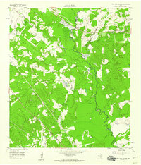
(12)- 1954 Map of Austin, 1964 Print
 1954 Austin1964 Print · USGSCentral Texas is captured during a period of steady growth as the capital city and its neighboring farm towns began to modernize. Researchers can trace historic rail corridors like the Southern Pacific RR or locate landmarks such as Bergstrom Air Force Base and Pilot Knob.4 unique versions available
 - 1956 Map of Bryan
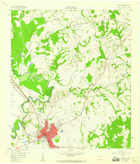
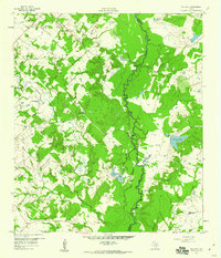
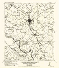 1956 Bryan1956 Print · USGSBrazos County is shown in the era of early college expansion and steam rail, centered on the growing campus of Texas A&M College. Genealogists and historians can trace defunct post offices and rural school sites like Benchley P.O., Woodville School, and the settlement of Boonville.
 - 1956 Map of Caldwell
 1956 Caldwell1956 Print · USGSThe Brazos Valley at the end of the Great War era shows a landscape defined by cotton gins and river crossings. Trace family roots and vanished landmarks like Moseley's Ferry, Stone City, and the Skrabonek Gin near Caldwell.
 - 1956 Map of Carlos
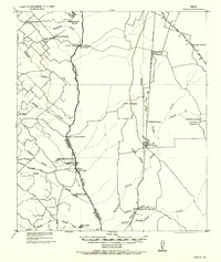 1956 Carlos1956 Print · USGSGrimes and Brazos counties appear here in a transition from military to civil use, mapping the rural landscape along the Navasota River. Genealogists and historians can trace early schoolhouses like Independence S.H. and vanished rail sidings such as Grimes Switch.
 - 1958 Map of Washington, 1960 Print
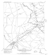
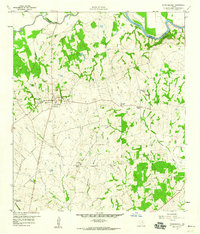
 1958 Washington1960 Print · USGSThe confluence of the Brazos and Navasota rivers defines this part of Texas in the late fifties. Genealogists and historians can locate old rural landmarks like Tennyson Cem, St Matthew Sch, and the riverside settlement of Washington.3 unique versions available
 - 1958 Map of Navasota, 1960 Print
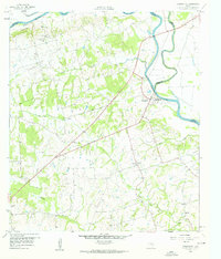
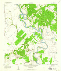
 1958 Navasota1960 Print · USGSNavasota thrived as a vital rail junction and river town in the late fifties, serving as a crossroads for several major Texas railroad lines. Genealogists can trace family landmarks and burial sites including Oakland Cemetery, Erwin Cem, and the Salem Missionary Ch.3 unique versions available
 - 1959 Map of Millican, 1960 Print
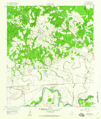 1959 Millican1960 Print · USGSThe Brazos Valley in the late fifties was a crossroads of major rail lines and river commerce. Genealogists and historians can trace the development of rail-side settlements like Millican and Allenfarm, or locate rural landmarks such as Brooks Chapel and Hidalgo Falls.4 unique versions available
 - 1959 Map of Clay, 1960 Print
 1959 Clay1960 Print · USGSNear the convergence of the Brazos and Yegua, this late-fifties survey reveals a landscape of winding river bends and vital rail junctions. Historians can trace the legacy of local settlements through Betts Ferry Cem, the rail lines of the Missouri Pacific, and the namesake Clay Pit.3 unique versions available
 - 1959 Map of Clear Lake, 1960 Print
 1959 Clear Lake1960 Print · USGSThe Navasota River bottomlands are captured here in the late fifties at the meeting of Brazos, Madison, and Grimes Counties. Researchers can trace rural landmarks like Williamson Cem, find old river transits at Democrat Crossing, or locate Brushy Lake.3 unique versions available
 - 1959 Map of Reliance, 1960 Print
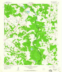
 1959 Reliance1960 Print · USGSBrazos and Grimes counties meet along the winding river bottomlands in the late fifties. Genealogists and local historians can trace the rural communities of Reliance and Harvey or locate the Stick Cem and Martin Prairie Ch.4 unique versions available
 - 1959 Map of Ferguson Crossing, 1960 Print
 1959 Ferguson Crossing1960 Print · USGSThe Brazos and Grimes county line along the Navasota River comes into focus in the late fifties, showcasing a rural Texas landscape of river bottoms and family landmarks. Genealogists and researchers can locate the Peach Creek Cem, the Rodeo Ground, and the historic namesake of Ferguson Crossing.3 unique versions available
 - 1959 Map of Independence, 1960 Print
 1959 Independence1960 Print · USGSTexas history remains etched into the landscape around Independence in the late fifties, from the original Baylor University State Park to the Gov Sam Houston Home. Trace family roots through rural landmarks like Sandy Hill, Union Hill Ch, and the Summers Cem.3 unique versions available
End of results
Showing maps 1-12 of 12
Top cities of Brazos County
- College Station historical maps
- Bryan historical maps
- Millican historical maps
- Kurten historical maps
- Wixon Valley historical maps
Frequently asked questions
- What are the different types of historical maps available for Brazos County?
- What is the oldest map of Brazos County?
- Where can I purchase historical maps of Brazos County for my home or office?
- Where can I download high-res historical maps of Brazos County?
- Are there historical topographic maps available for Brazos County?
- Is there historical aerial imagery available for Brazos County?
- Where are historical maps of Brazos County sourced from?