1920s Maps of Burnet County, Texas
Explore 4 historic maps of Burnet County from the 1920s. These maps offer a rare glimpse into what life looked like during the 1920s — showing old roads, neighborhoods, homes, and landmarks that have changed or disappeared over time.
Whether you're researching your family's past, planning a metal detecting trip, or studying how Burnet County's landscape evolved across the 1920s, these high-resolution maps are a powerful tool for exploring the history of this region.
- Focus on a specific era: All maps on this page are from the 1920s, giving you a focused view of this time period.
- See what’s changed: Compare century-old streets, trails, and buildings to today's modern landscape using overlays and satellite layers.
- Research with precision: Use these maps for genealogy, historical research, land use analysis, or educational projects.
- View, download, or print: Maps are fully viewable online in high resolution, and can be downloaded or printed for your own records.
Start exploring Burnet County's history through authentic maps from the 1920s. This is your window into the past.
Burnet County, TX maps
(4)- 1925 Map of Burnet 3-b
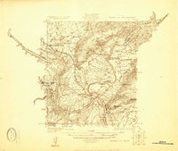 1925 Burnet 3-b1925 Print · USGSThe confluence of the Colorado and Llano Rivers defines this central Texas landscape in the mid-twenties. Genealogists can trace early rural life through family-named landmarks like Hoover Valley, the Pack Saddle School, and Mason Crossing.
 - 1925 Map of Burnet 2-c
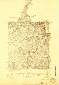 1925 Burnet 2-c1925 Print · USGSLlano and Burnet counties are defined by the winding course of the Colorado River in the mid-twenties. Genealogists and local historians can trace the foundations of riverside life at Bluffton, including Bluffton Cemetery and the old Saltworks Ford.
 - 1925 Map of Burnet 3-d
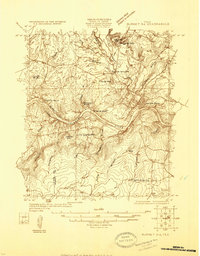 1925 Burnet 3-d1925 Print · USGSTexas hill country in the mid-twenties centers on the river-bend industry of the Colorado. Researchers can trace the early layout of Marble Falls and locate historical landmarks like Granite Mtn Sta, Rennison Knob, and Flatrock Spring.
 - 1929 Map of Marble Falls
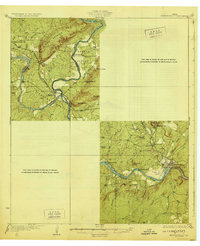 1929 Marble Falls1929 Print · USGSThe Texas Hill Country at the end of the 1920s shows the original river channels and granite industry before major reservoir construction. Trace early rail stops like Wood Spur and local landmarks such as Granite Mtn and Hoover Sch.
End of results
Showing maps 1-4 of 4
Top cities of Burnet County
- Marble Falls historical maps
- Burnet historical maps
- Granite Shoals historical maps
- Meadowlakes historical maps
- Bertram historical maps
- Cottonwood Shores historical maps
See more
Frequently asked questions
- What are the different types of historical maps available for Burnet County?
- What is the oldest map of Burnet County?
- Where can I purchase historical maps of Burnet County for my home or office?
- Where can I download high-res historical maps of Burnet County?
- Are there historical topographic maps available for Burnet County?
- Is there historical aerial imagery available for Burnet County?
- Where are historical maps of Burnet County sourced from?