1900s (20th Century) Maps of Burnet County, Texas
Explore 61 historic maps of Burnet County from the 1900s (20th Century). These maps offer a rare glimpse into what life looked like during the 1900s — showing old roads, neighborhoods, homes, and landmarks that have changed or disappeared over time.
Whether you're researching your family's past, planning a metal detecting trip, or studying how Burnet County's landscape evolved across the 1900s, these high-resolution maps are a powerful tool for exploring the history of this region.
- Focus on a specific era: All maps on this page are from the 1900s, giving you a focused view of this time period.
- See what’s changed: Compare century-old streets, trails, and buildings to today's modern landscape using overlays and satellite layers.
- Research with precision: Use these maps for genealogy, historical research, land use analysis, or educational projects.
- View, download, or print: Maps are fully viewable online in high resolution, and can be downloaded or printed for your own records.
Start exploring Burnet County's history through authentic maps from the 1900s. This is your window into the past.
Burnet County, TX maps
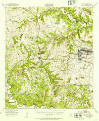
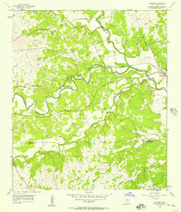
(61)- 1903 Map of Burnet
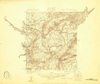
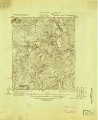
 1903 Burnet1903 Print · USGSThe Texas Hill Country at the turn of the century shows a landscape of river-side industry and early rail expansion. Trace the historic Houston and Texas Central Railroad line through Burnet and Bertram or locate long-standing landmarks like Morman Mill and Tanyard Crossing.
 - 1909 Map of Burnet
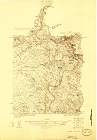
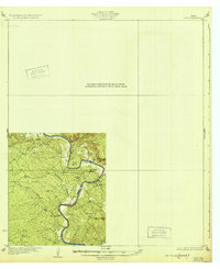
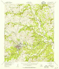
 1909 Burnet1909 Print · USGSThe Texas Hill Country at the turn of the century shows a landscape of river crossings and rail towns before the creation of the Highland Lakes. Genealogists can locate family-named landmarks like Morman Mill, Tumlinson, and rural schoolhouses such as Berry School or Sunny Lane.3 unique versions available
 - 1925 Map of Burnet 3-b
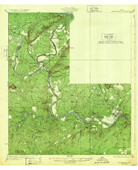
 1925 Burnet 3-b1925 Print · USGSThe confluence of the Colorado and Llano Rivers defines this central Texas landscape in the mid-twenties. Genealogists can trace early rural life through family-named landmarks like Hoover Valley, the Pack Saddle School, and Mason Crossing.
 - 1925 Map of Burnet 2-c
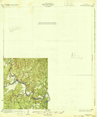
 1925 Burnet 2-c1925 Print · USGSLlano and Burnet counties are defined by the winding course of the Colorado River in the mid-twenties. Genealogists and local historians can trace the foundations of riverside life at Bluffton, including Bluffton Cemetery and the old Saltworks Ford.
 - 1925 Map of Burnet 3-d
 1925 Burnet 3-d1925 Print · USGSTexas hill country in the mid-twenties centers on the river-bend industry of the Colorado. Researchers can trace the early layout of Marble Falls and locate historical landmarks like Granite Mtn Sta, Rennison Knob, and Flatrock Spring.
 - 1929 Map of Marble Falls
 1929 Marble Falls1929 Print · USGSThe Texas Hill Country at the end of the 1920s shows the original river channels and granite industry before major reservoir construction. Trace early rail stops like Wood Spur and local landmarks such as Granite Mtn and Hoover Sch.
 - 1930 Map of Blanco-1
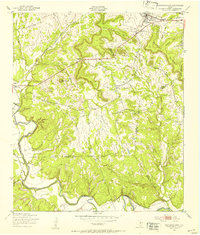
 1930 Blanco-11930 Print · USGSCentral Texas river valleys appear in high detail during the early 1930s, showing the landscape before later reservoir projects. Trace the original paths of the Colorado River and Pedernales River past Pleasant Grove Sch and Buggy Ford.
 - 1931 Map of Marble Falls
 1931 Marble Falls1931 Print · USGSThe Texas Hill Country at the start of the 1930s is revealed here as a landscape of isolated peaks and winding river bends. Genealogists and local historians can trace family roots near Gaddy Crossing, the Upshaw settlement, or old schools like Sandy Mtn Sch.
 - 1932 Map of Tow
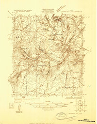
 1932 Tow1932 Print · USGSThe Colorado River valley along the Llano and Burnet county line is captured here in the mid-1920s, before the landscape was altered by dams. Researchers can locate the settlement of Bluffton, the Bluffton Sch, and the river crossing at Saltworks Ford.2 unique versions available
 - 1932 Map of Marble Falls
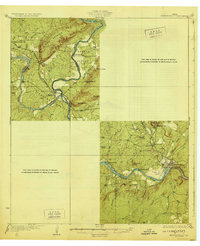
 1932 Marble Falls1932 Print · USGSThe Colorado River valley at the LLano and Burnet County line is shown here in the early thirties, before the creation of the modern lakes. Researchers can trace the Southern Pacific rail line through Kingsland and locate rural schools like La Vista School and Hoover School.2 unique versions available
 - 1932 Map of Bertram
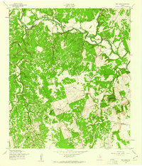
 1932 Bertram1932 Print · USGSBurnet County’s river-bound landscape is documented here in the early 1930s, featuring the rural life of Smithwick and the winding COLORADO RIVER. Genealogists can trace family footprints at Pleasant Valley Sch, Hale Ch, and historic river fords like SINGLETON CROSSING.2 unique versions available
 - 1947 Map of Fort Hood
 1947 Fort Hood1947 Print · USGSCoryell and Lampasas Counties are shown here during the post-war expansion of military and rail infrastructure. Researchers can trace the layout of Fort Hood alongside rural landmarks like Willow Springs School, Starkle Cemetery, and the Variety Club Boys Ranch.
 - 1947 Map of Copperas Cove, 1953 Print
 1947 Copperas Cove1953 Print · USGSCopperas Cove and Kempner are shown in the late 1940s as rural centers alongside the growing military presence at Fort Hood. Genealogists can locate family sites at Starkie Cem and Smith Cem or trace the early course of the Lampasas River.
 - 1954 Map of Brownwood, 1955 Print
 1954 Brownwood1955 Print · USGSCentral Texas in the early fifties shows a landscape of rail-linked cattle towns and winding river valleys before modern highway expansion. Genealogists and historians can trace family-named peaks and vanished rail stops like Trickham, Santa Anna, and the Brady Mountains.3 unique versions available
 - 1954 Map of Lampasas, 1956 Print
 1954 Lampasas1956 Print · USGSLampasas and the surrounding ranchlands are shown here in the mid-fifties, centered on the confluence of several creeks and the rail corridor. Researchers can trace the layout of Kempner and Rumley, find rural landmarks like Clay Rock Ch, or locate family plots at Garner Cem.
 - 1954 Map of Lampasas, 1957 Print
 1954 Lampasas1957 Print · USGSMid-century Lampasas, Texas, serves as a railroad and highway crossroads where the hills meet the creek valleys. Trace the routes of the Santa Fe Railroad and find local landmarks like Hancock Park and Cook Cem.
 - 1954 Map of Kempner, 1957 Print
 1954 Kempner1957 Print · USGSKempner and the Lampasas River valley are captured in the mid-fifties, showing a landscape shaped by the railroad and river crossings. Trace family history at Pickett Cem or explore rail landmarks like Deadmans Cut and the siding at Shortall.2 unique versions available
 - 1954 Map of Llano, 1964 Print
 1954 Llano1964 Print · USGSThe Texas Hill Country and Highland Lakes appear in the mid-fifties, just as new reservoirs began reshaping the landscape. Trace ranching history and river routes from Mason to Llano, or follow the Gulf Colorado and Santa Fe RR past Buchanan Lake.2 unique versions available
 - 1954 Map of Waco, 1964 Print
 1954 Waco1964 Print · USGSCentral Texas during the mid-fifties shows a landscape defined by the expansion of Fort Hood Military Reservation and the Brazos river system. Trace the rail lines and early airfields like James Connally Air Force Base and settlements like Temple or McGregor.2 unique versions available
 - 1954 Map of Austin, 1964 Print
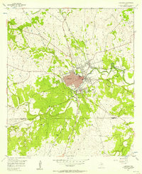
 1954 Austin1964 Print · USGSCentral Texas is captured during a period of steady growth as the capital city and its neighboring farm towns began to modernize. Researchers can trace historic rail corridors like the Southern Pacific RR or locate landmarks such as Bergstrom Air Force Base and Pilot Knob.4 unique versions available
 - 1955 Map of Llano
 1955 Llano1955 Print · USGSCentral Texas and the Hill Country are seen here during the mid-1950s growth of the Highland Lakes. Trace old settlements and geologic landmarks from Enchanted Rock and Longhorn Cavern to the small community of Luckenbach.
 - 1955 Map of Waco
 1955 Waco1955 Print · USGSCentral Texas at the peak of the Cold War reveals a landscape defined by military expansion and major water projects. Researchers can trace the footprints of Fort Hood, the waters of Lake Waco, and regional hubs like Temple or Mexia.
 - 1956 Map of Llano, 1976 Print
 1956 Llano1976 Print · USGSThe Texas Hill Country comes alive in this mid-seventies survey of the Llano Uplift and Colorado River lakes. Genealogists and historians can trace family roots through settlements like Luckenbach and Castell or locate the famed L B J Ranch and Enchanted Rock.
 - 1958 Map of Ding Dong, 1961 Print
 1958 Ding Dong1961 Print · USGSThe Lampasas River valley in Central Texas comes to life in this mid-century survey, showcasing rural life along the Bell and Williamson county line. Trace the history of settlements like Ding Dong and Maxdale, or locate the Rock Creek Cem and the Thompson Youngblood Ranch Airport.4 unique versions available
 - 1958 Map of Briggs, 1961 Print
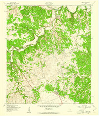 1958 Briggs1961 Print · USGSNear the Lampasas River in the late 1950s, this area of Burnet County shows a quiet landscape of ranching and river-bottom settlements. Genealogists can locate Gillum Cem and trace the rural surroundings of Oakalla and Briggs.2 unique versions available
Showing maps 1-25 of 61
Top cities of Burnet County
- Marble Falls historical maps
- Burnet historical maps
- Granite Shoals historical maps
- Meadowlakes historical maps
- Bertram historical maps
- Cottonwood Shores historical maps
See more
Frequently asked questions
- What are the different types of historical maps available for Burnet County?
- What is the oldest map of Burnet County?
- Where can I purchase historical maps of Burnet County for my home or office?
- Where can I download high-res historical maps of Burnet County?
- Are there historical topographic maps available for Burnet County?
- Is there historical aerial imagery available for Burnet County?
- Where are historical maps of Burnet County sourced from?