1930s Maps of Burnet County, Texas
Explore 5 historic maps of Burnet County from the 1930s. These maps offer a rare glimpse into what life looked like during the 1930s — showing old roads, neighborhoods, homes, and landmarks that have changed or disappeared over time.
Whether you're researching your family's past, planning a metal detecting trip, or studying how Burnet County's landscape evolved across the 1930s, these high-resolution maps are a powerful tool for exploring the history of this region.
- Focus on a specific era: All maps on this page are from the 1930s, giving you a focused view of this time period.
- See what’s changed: Compare century-old streets, trails, and buildings to today's modern landscape using overlays and satellite layers.
- Research with precision: Use these maps for genealogy, historical research, land use analysis, or educational projects.
- View, download, or print: Maps are fully viewable online in high resolution, and can be downloaded or printed for your own records.
Start exploring Burnet County's history through authentic maps from the 1930s. This is your window into the past.
Burnet County, TX maps
(5)- 1930 Map of Blanco-1
 1930 Blanco-11930 Print · USGSCentral Texas river valleys appear in high detail during the early 1930s, showing the landscape before later reservoir projects. Trace the original paths of the Colorado River and Pedernales River past Pleasant Grove Sch and Buggy Ford.
 - 1931 Map of Marble Falls
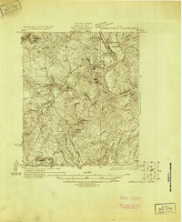 1931 Marble Falls1931 Print · USGSThe Texas Hill Country at the start of the 1930s is revealed here as a landscape of isolated peaks and winding river bends. Genealogists and local historians can trace family roots near Gaddy Crossing, the Upshaw settlement, or old schools like Sandy Mtn Sch.
 - 1932 Map of Tow
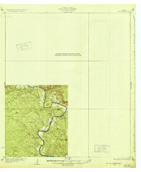 1932 Tow1932 Print · USGSThe Colorado River valley along the Llano and Burnet county line is captured here in the mid-1920s, before the landscape was altered by dams. Researchers can locate the settlement of Bluffton, the Bluffton Sch, and the river crossing at Saltworks Ford.2 unique versions available
 - 1932 Map of Marble Falls
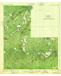 1932 Marble Falls1932 Print · USGSThe Colorado River valley at the LLano and Burnet County line is shown here in the early thirties, before the creation of the modern lakes. Researchers can trace the Southern Pacific rail line through Kingsland and locate rural schools like La Vista School and Hoover School.2 unique versions available
 - 1932 Map of Bertram
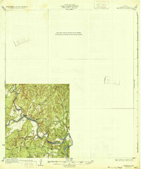 1932 Bertram1932 Print · USGSBurnet County’s river-bound landscape is documented here in the early 1930s, featuring the rural life of Smithwick and the winding COLORADO RIVER. Genealogists can trace family footprints at Pleasant Valley Sch, Hale Ch, and historic river fords like SINGLETON CROSSING.2 unique versions available
End of results
Showing maps 1-5 of 5
Top cities of Burnet County
- Marble Falls historical maps
- Burnet historical maps
- Granite Shoals historical maps
- Meadowlakes historical maps
- Bertram historical maps
- Cottonwood Shores historical maps
See more
Frequently asked questions
- What are the different types of historical maps available for Burnet County?
- What is the oldest map of Burnet County?
- Where can I purchase historical maps of Burnet County for my home or office?
- Where can I download high-res historical maps of Burnet County?
- Are there historical topographic maps available for Burnet County?
- Is there historical aerial imagery available for Burnet County?
- Where are historical maps of Burnet County sourced from?