1900s (20th Century) Maps of Indian Lake, Texas
Explore 13 historic maps of Indian Lake from the 1900s (20th Century). These maps offer a rare glimpse into what life looked like during the 1900s — showing old roads, neighborhoods, homes, and landmarks that have changed or disappeared over time.
Whether you're researching your family's past, planning a metal detecting trip, or studying how Indian Lake's landscape evolved across the 1900s, these high-resolution maps are a powerful tool for exploring the history of this region.
- Focus on a specific era: All maps on this page are from the 1900s, giving you a focused view of this time period.
- See what’s changed: Compare century-old streets, trails, and buildings to today's modern landscape using overlays and satellite layers.
- Research with precision: Use these maps for genealogy, historical research, land use analysis, or educational projects.
- View, download, or print: Maps are fully viewable online in high resolution, and can be downloaded or printed for your own records.
Start exploring Indian Lake's history through authentic maps from the 1900s. This is your window into the past.
Indian Lake, TX maps
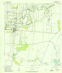
(13)- 1930 Map of Los Fresnos
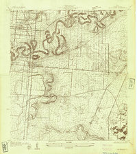 1930 Los Fresnos1930 Print · USGSCameron County's agricultural and rail landscape is captured here in the early thirties. Genealogists can trace early homesteads near Los Fresnos or locate landmarks like the Palo Alto Battlefield Monument and White House Sch.
 - 1930 Map of Barreda
 1930 Barreda1930 Print · USGSCoastal South Texas is seen here during the irrigation boom of the early thirties, showing the intricate oxbows and ranch lands. Researchers can trace the St Louis Brownsville and Mexico Railway past Barreda and the Old Military Road.
 - 1936 Map of Los Fresnos
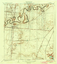 1936 Los Fresnos1936 Print · USGSThe Lower Rio Grande Valley landscape comes into focus during the 1930s, highlighting a network of irrigation ditches and historical battle sites. Researchers can trace the winding Resaca de los Cuates or locate vanished landmarks like the Palo Alto Battlefield Monument and White House Sch.3 unique versions available
 - 1936 Map of Barreda
 1936 Barreda1936 Print · USGSThe Lower Rio Grande Valley's unique oxbow landscape is captured here in the mid-1930s, showing a network of resacas and early irrigation works. Researchers can trace family-named lands like Soldado Ranch and Naranjas Ranch or locate the old Airways Beacon near Olmito.2 unique versions available
 - 1945 Map of Olmito
 1945 Olmito1945 Print · USGSCameron County in the mid-forties shows a landscape shaped by the winding resacas of the Rio Grande Valley. Genealogists and historians can trace the development of the Missouri Pacific Line and local landmarks like Barreda State Park and Soldado Ranch.
 - 1953 Map of Brownsville
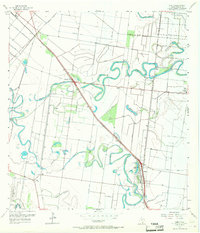
 1953 Brownsville1953 Print · USGSSouth Texas ranchlands and the Lower Rio Grande Valley are captured here in the early fifties as the region's irrigation and shipping networks expanded. Genealogists and historians can trace family landholdings like Tecolote Ranch or follow the route of the St Louis Brownsville and Mexico rail line through Sebastian and Yturria.
 - 1955 Map of Los Fresnos, 1957 Print
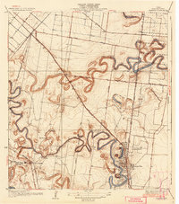
 1955 Los Fresnos1957 Print · USGSCoastal Cameron County in the mid-1950s shows a landscape transitioning between its martial history and modern agricultural expansion. Trace the Palo Alto Battlefield and find local landmarks like Wardner Ranch, Charco Honda, and Los Fresnos Sch.3 unique versions available
 - 1956 Map of Olmito, 1957 Print
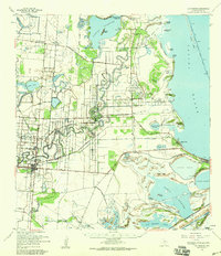
 1956 Olmito1957 Print · USGSIn the mid-1950s, the Cameron County landscape was a complex network of ancient resacas and modern irrigation canals. Trace family-named landmarks and settlements along the Missouri Pacific rail line, including Russeltown, Villa Cavazos, and Olmito Lake.5 unique versions available
 - 1956 Map of Los Fresnos, 1959 Print
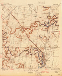
 1956 Los Fresnos1959 Print · USGSCoastal Cameron County in the mid-fifties is a landscape of ancient river channels and historic ranchlands stretching toward the Laguna Madre. Researchers can trace the Palo Alto Battlefield, local Soldiers Cem, and ranching outposts like La Tina Ranch.
 - 1956 Map of Brownsville, 1969 Print
 1956 Brownsville1969 Print · USGSThe Texas-Mexico borderlands and the Gulf coast come alive in this mid-century survey of the Rio Grande Valley. Genealogists and historians can trace the reach of the Missouri Pacific rail lines through citrus country to schools like Las Yescas and Palm Grove.2 unique versions available
 - 1956 Map of Port Isabel, 1983 Print
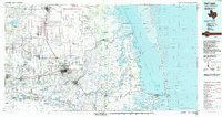
 1956 Port Isabel1983 Print · USGSCoastal Texas and the Rio Grande Valley are shown here in the mid-twentieth century as the region balanced intensive agriculture with maritime trade. Researchers can trace historic rail lines like the SOUTHERN PACIFIC and locate rural landmarks such as Las Yescas Sch or the Armstrong Ranch.
 - 1962 Map of Brownsville
 1962 Brownsville1962 Print · USGSThe Lower Rio Grande Valley in the early sixties was a landscape of coastal wildlands, booming oil fields, and international border commerce. Trace the development of this frontier region through landmarks like Harlingen Air Force Base, Boca Chica Island, and the Willamar Oil Field.
 - 1992 Map of Harlingen
 1992 Harlingen1992 Print · USGSSouth Texas in the early nineties shows a landscape defined by industrial growth and coastal conservation along the Rio Grande. Trace the rail lines of the Missouri Pacific through Raymondville or locate the historic Palo Alto Battlefield near Port Isabel.
End of results
Showing maps 1-13 of 13
Top cities near Indian Lake
- Brownsville historical maps
- Harlingen historical maps
- San Benito historical maps
- Cameron Park historical maps
- Los Fresnos historical maps
- Port Isabel historical maps
See more
Frequently asked questions
- What are the different types of historical maps available for Indian Lake?
- What is the oldest map of Indian Lake?
- Where can I purchase historical maps of Indian Lake for my home or office?
- Where can I download high-res historical maps of Indian Lake?
- Are there historical topographic maps available for Indian Lake?
- Is there historical aerial imagery available for Indian Lake?
- Where are historical maps of Indian Lake sourced from?