1960s Maps of Hughes Springs, Texas
Explore 4 historic maps of Hughes Springs from the 1960s. These maps offer a rare glimpse into what life looked like during the 1960s — showing old roads, neighborhoods, homes, and landmarks that have changed or disappeared over time.
Whether you're researching your family's past, planning a metal detecting trip, or studying how Hughes Springs's landscape evolved across the 1960s, these high-resolution maps are a powerful tool for exploring the history of this region.
- Focus on a specific era: All maps on this page are from the 1960s, giving you a focused view of this time period.
- See what’s changed: Compare century-old streets, trails, and buildings to today's modern landscape using overlays and satellite layers.
- Research with precision: Use these maps for genealogy, historical research, land use analysis, or educational projects.
- View, download, or print: Maps are fully viewable online in high resolution, and can be downloaded or printed for your own records.
Start exploring Hughes Springs's history through authentic maps from the 1960s. This is your window into the past.
Hughes Springs, TX maps
(4)- 1962 Map of Avinger, 1964 Print
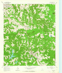 1962 Avinger1964 Print · USGSEast Texas rail and timber lands are frozen in time during the early sixties, centered on the junction of Avinger and Hughes Springs. Genealogists and local historians can trace rural roots at Mt Moriah Ch, Traylor Sch, and family landmarks like Donaldson Mountain.2 unique versions available
 - 1962 Map of Lone Star, 1964 Print
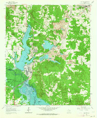 1962 Lone Star1964 Print · USGSMorris County in the early sixties was a hub of East Texas industry and rural life, from the growing town of Lone Star to the heavy iron works. Researchers can trace the massive Steel Plant, local landmarks like Hospital in the Pines, and old family burial grounds including South Union Cem.2 unique versions available
 - 1964 Map of Daingerfield, 1967 Print
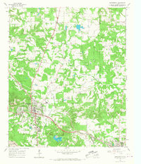 1964 Daingerfield1967 Print · USGSMorris County was a hub of rail activity and iron-ore mining in the mid-sixties, centered on the growing town of Daingerfield. Genealogists and historians can trace the foundations of local life at Daingerfield State Park, the Black Mountain Mine, and several rural landmarks like Bradfield Ch.2 unique versions available
 - 1965 Map of Sardis, 1967 Print
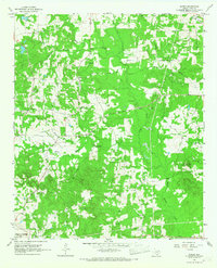 1965 Sardis1967 Print · USGSCass County, Texas, is captured here in the mid-1960s as a region of timbered creeks and small rural settlements. Researchers can locate family landmarks like the Crossroads Community Center, Mt Olive Ch, and the Old Union Hill Cem.
End of results
Showing maps 1-4 of 4
Top cities near Hughes Springs
- Daingerfield historical maps
- Lone Star historical maps
- Naples historical maps
- Ore City historical maps
- Omaha historical maps
- Avinger historical maps
See more
Frequently asked questions
- What are the different types of historical maps available for Hughes Springs?
- What is the oldest map of Hughes Springs?
- Where can I purchase historical maps of Hughes Springs for my home or office?
- Where can I download high-res historical maps of Hughes Springs?
- Are there historical topographic maps available for Hughes Springs?
- Is there historical aerial imagery available for Hughes Springs?
- Where are historical maps of Hughes Springs sourced from?