
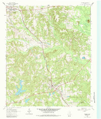
1962 Map of Avinger
USGS Topo · Published 1964About this map
Hughes Springs and Avinger anchor this East Texas landscape, connected by the diagonal route of the Louisiana and Arkansas railroad. The terrain is defined by a dense network of tributaries including Black Cypress Creek, Hughes Creek, and Cawhorn Creek, which flow through the wooded hills of Cass and Marion counties. This early 1960s survey captures the area before extensive modern development, highlighting rural landmarks such as the Traylor Sch and Mt Moriah Ch near Hickory Hill. Significant water features like Simpson Lake and Pruitt Lake appear alongside smaller local landmarks like the Flowing Well and Roadside Park. The map also traces the industrial footprint of the era through a prominent pipeline and the Sewage Disposal facility near the northern municipal boundary. The topography is marked by distinct rises such as Donaldson Mountain and Mt Moriah, providing a clear view of the natural drainage patterns of the region.
Find a feature on this map
32 named features on this map. Tap any name to fly to it.
Don’t see what you’re looking for? This feature index may not catch every label — zoom into the map to look around manually.
Map Details
Editions of this 1962 Avinger Map
2 editions found
Other maps of this area

1910 · Linden
USGS Topo · 1:62,500

1914 · Daingerfield
USGS Topo · 1:62,500

1953 · Texarkana
USGS Topo · 1:250,000

1956 · Texarkana
USGS Topo · 1:250,000

1956 · Tyler
USGS Topo · 1:250,000

1961 · Cunningham Creek
USGS Topo · 1:24,000

1961 · Lassater
USGS Topo · 1:24,000

1962 · Kellyville
USGS Topo · 1:24,000

1962 · Ore City
USGS Topo · 1:24,000

1962 · Lone Star
USGS Topo · 1:24,000