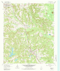
1962 Map of Avinger
USGS Topo · Published 1982About this map
The Louisiana and Arkansas railroad corridor anchors this 1962 survey of the East Texas timberlands, linking the growing community of Hughes Springs in the northwest to Avinger in the south. The landscape is defined by its creek-carved topography, where the Cass Co and Marion Co line crosses through heavily wooded drainages. Rural life is evidenced by a network of community landmarks, including the Union Hill Ch and Mt Moriah Ch, alongside legacy sites like the Duncan Cem and Traylor Sch. Water management is a visible priority for the era, shown through the controlled inundation areas of Simpson Lake and Pruitt Lake, both featuring noted spillway elevations. The presence of settlements like Love and Turkey Creek among the ridges of Donaldson Mountain illustrates the persistent pattern of small-scale upland habitation characteristic of the Piney Woods during the mid-century.
Find a feature on this map
35 named features on this map. Tap any name to fly to it.
Don’t see what you’re looking for? This feature index may not catch every label — zoom into the map to look around manually.
Map Details
Editions of this 1962 Avinger Map
2 editions found
Other maps of this area

1910 · Linden
USGS Topo · 1:62,500

1914 · Daingerfield
USGS Topo · 1:62,500

1953 · Texarkana
USGS Topo · 1:250,000

1956 · Texarkana
USGS Topo · 1:250,000

1956 · Tyler
USGS Topo · 1:250,000

1961 · Cunningham Creek
USGS Topo · 1:24,000

1961 · Lassater
USGS Topo · 1:24,000

1962 · Kellyville
USGS Topo · 1:24,000

1962 · Avinger
USGS Topo · 1:24,000

1962 · Ore City
USGS Topo · 1:24,000