1910s Maps of Chambers County, Texas
Explore 6 historic maps of Chambers County from the 1910s. These maps offer a rare glimpse into what life looked like during the 1910s — showing old roads, neighborhoods, homes, and landmarks that have changed or disappeared over time.
Whether you're researching your family's past, planning a metal detecting trip, or studying how Chambers County's landscape evolved across the 1910s, these high-resolution maps are a powerful tool for exploring the history of this region.
- Focus on a specific era: All maps on this page are from the 1910s, giving you a focused view of this time period.
- See what’s changed: Compare century-old streets, trails, and buildings to today's modern landscape using overlays and satellite layers.
- Research with precision: Use these maps for genealogy, historical research, land use analysis, or educational projects.
- View, download, or print: Maps are fully viewable online in high resolution, and can be downloaded or printed for your own records.
Start exploring Chambers County's history through authentic maps from the 1910s. This is your window into the past.
Chambers County, TX maps
(6)- 1916 Map of Morgan Point
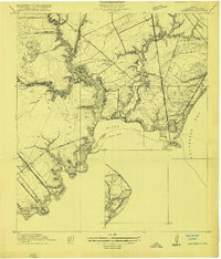
 1916 Morgan Point1916 Print · USGSCoastal Harris and Chambers counties are shown in the years following the opening of the ship channel, when ferries and family landmarks still defined the shoreline. Genealogists and researchers can trace early settlements and navigation aids, from the Goose Creek School and Goose Creek Ferry to the landing at Morgan Point.
 - 1916 Map of Seabrook
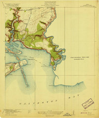
 1916 Seabrook1916 Print · USGSThe Galveston Bay shoreline comes to life in the years before heavy industrialization, showing the early coastal developments of Seabrook and Bayview. Genealogists can trace the Old Middle Bayou School and early rail lines like the Galveston Houston Electric Ry.2 unique versions available
 - 1916 Map of Cedar Bayou
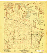
 1916 Cedar Bayou1916 Print · USGSThe coastal plains of Harris and Chambers counties are captured here just before the era of major regional change. Trace the early school at Ellis League School, find ferry crossings at Milam Bend, and follow the Barbers Hill Road through the bayou country.
 - 1916 Map of La Porte
 1916 La Porte1916 Print · USGSCoastal Harris County is captured here during a period of rapid maritime and rail expansion just before the end of the Great War. Genealogists and historians can trace early property divisions and rail stops from Deer Park to the waters of Sylvan Beach and the San Jacinto Battlefield.2 unique versions available
 - 1919 Map of Morgan Point
 1919 Morgan Point1919 Print · USGSTexas's coastal industrial frontier comes to life just before the region's massive growth, showing the vital waterways of the bay. Trace the early footprints of Goose Creek, the railroad terminus at Bay Ridge, and the original Goose Creek School.2 unique versions available
 - 1919 Map of Cedar Bayou
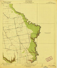 1919 Cedar Bayou1919 Print · USGSHarris County at the end of the Great War shows a transition from rural river life to an emerging road network. Genealogists and researchers can trace local landmarks like the Ellis League School and historical crossings such as Williams Ferry and Cedar Bayou.2 unique versions available
End of results
Showing maps 1-6 of 6
Top cities of Chambers County
- Mont Belvieu historical maps
- Winnie historical maps
- Beach City historical maps
- Anahuac historical maps
- Old River-Winfree historical maps
- Cove historical maps
Frequently asked questions
- What are the different types of historical maps available for Chambers County?
- What is the oldest map of Chambers County?
- Where can I purchase historical maps of Chambers County for my home or office?
- Where can I download high-res historical maps of Chambers County?
- Are there historical topographic maps available for Chambers County?
- Is there historical aerial imagery available for Chambers County?
- Where are historical maps of Chambers County sourced from?