1980s Maps of Chambers County, Texas
Explore 8 historic maps of Chambers County from the 1980s. These maps offer a rare glimpse into what life looked like during the 1980s — showing old roads, neighborhoods, homes, and landmarks that have changed or disappeared over time.
Whether you're researching your family's past, planning a metal detecting trip, or studying how Chambers County's landscape evolved across the 1980s, these high-resolution maps are a powerful tool for exploring the history of this region.
- Focus on a specific era: All maps on this page are from the 1980s, giving you a focused view of this time period.
- See what’s changed: Compare century-old streets, trails, and buildings to today's modern landscape using overlays and satellite layers.
- Research with precision: Use these maps for genealogy, historical research, land use analysis, or educational projects.
- View, download, or print: Maps are fully viewable online in high resolution, and can be downloaded or printed for your own records.
Start exploring Chambers County's history through authentic maps from the 1980s. This is your window into the past.
Chambers County, TX maps
(8)- 1982 Map of Mont Belvieu
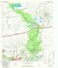 1982 Mont Belvieu1982 Print · USGSThe industrial and residential growth of the Texas Gulf Coast is captured here in the early eighties. Genealogists and historians can trace family sites like Busch Cem and Fisher Cem or locate the sprawling Oil and Gas Field and refinery works.
 - 1982 Map of Morgans Point
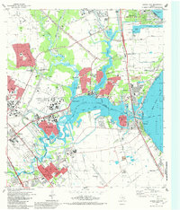
 1982 Morgans Point1982 Print · USGSBaytown and its surrounding coastal communities are shown here at the start of the 1980s, balancing industrial expansion with residential life. Genealogists and historians can trace neighborhood developments around Lee High Sch, the Hill of Rest Cem, and the specialized maritime docks at Barbours Cut.
 - 1982 Map of Sheeks
 1982 Sheeks1982 Print · USGSCoastal Texas industry and rural life meet in the early eighties as petroleum production and complex canal systems reshape the Liberty County landscape. Genealogists and historians can locate the Harvey Cem, the Esperson D.O.M.E. Oil Field, and the Sheeks rail siding.
 - 1982 Map of League City
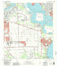
 1982 League City1982 Print · USGSThe coastal corridor south of Houston was a hub of aerospace innovation and maritime industry in the early eighties. Researchers can locate the NASA Space Center, the Houston Gulf Airport, and local landmarks like Fairview Cem or the Southern Pacific tracks.3 unique versions available
 - 1982 Map of Bacliff
 1982 Bacliff1982 Print · USGSUpper Galveston Bay and the Texas coast come alive in this early eighties survey of the bustling Houston maritime corridor. Genealogists and local historians can trace the development of Bacliff, San Leon, and Seabrook alongside the heavy industrial footprint of the Oil Field.
 - 1982 Map of La Porte, 1983 Print
 1982 La Porte1983 Print · USGSThe industrial and maritime heart of the Texas coast comes into focus in the early eighties as the ship channel drives the local economy. Trace family history and regional growth at La Porte, San Jacinto State Park, and the Wooster Cem.
 - 1983 Map of Galveston
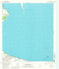
 1983 Galveston1983 Print · USGSThe Texas Gulf Coast comes into sharp focus in the early eighties, centered on the thriving maritime and industrial hubs of Galveston and Texas City. Trace coastal change and land use through landmarks like Fort San Jacinto, the Texas City Dike, and the expansive Galveston Island State Park.
 - 1983 Map of Anahuac
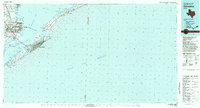
 1983 Anahuac1983 Print · USGSThe Upper Texas Coast and its energy-driven landscape are detailed here in the early eighties. Genealogists and historians can trace coastal settlements like Anahuac and Winnie alongside the storied Spindletop Oil Field and the Anahuac National Wildlife Refuge.2 unique versions available
End of results
Showing maps 1-8 of 8
Top cities of Chambers County
- Mont Belvieu historical maps
- Winnie historical maps
- Beach City historical maps
- Anahuac historical maps
- Old River-Winfree historical maps
- Cove historical maps
Frequently asked questions
- What are the different types of historical maps available for Chambers County?
- What is the oldest map of Chambers County?
- Where can I purchase historical maps of Chambers County for my home or office?
- Where can I download high-res historical maps of Chambers County?
- Are there historical topographic maps available for Chambers County?
- Is there historical aerial imagery available for Chambers County?
- Where are historical maps of Chambers County sourced from?