1900s (20th Century) Maps of Coleman County, Texas
Explore 50 historic maps of Coleman County from the 1900s (20th Century). These maps offer a rare glimpse into what life looked like during the 1900s — showing old roads, neighborhoods, homes, and landmarks that have changed or disappeared over time.
Whether you're researching your family's past, planning a metal detecting trip, or studying how Coleman County's landscape evolved across the 1900s, these high-resolution maps are a powerful tool for exploring the history of this region.
- Focus on a specific era: All maps on this page are from the 1900s, giving you a focused view of this time period.
- See what’s changed: Compare century-old streets, trails, and buildings to today's modern landscape using overlays and satellite layers.
- Research with precision: Use these maps for genealogy, historical research, land use analysis, or educational projects.
- View, download, or print: Maps are fully viewable online in high resolution, and can be downloaded or printed for your own records.
Start exploring Coleman County's history through authentic maps from the 1900s. This is your window into the past.
Coleman County, TX maps
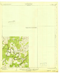
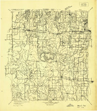
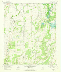
(50)- 1924 Map of Eden 1-a
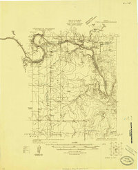 1924 Eden 1-a1924 Print · USGSThe Concho and Colorado River confluence area was a landscape of river crossings and small schoolhouse districts in the mid-1920s. Genealogists can trace early homesteads near Stacy and Doole, or locate landmarks like Bethel Church and the Hardin School.
 - 1924 Map of Brownwood Reservoir Site
 1924 Brownwood Reservoir Site1924 Print · USGSThe river valleys of Brown County are captured here in the mid-1920s during the planning of a major reservoir project. Researchers can trace the original landscape of Pecan Bayou and locate vanished landmarks like Rocky Church and Frys Ford before the waters rose.
 - 1924 Map of Brady 2-a
 1924 Brady 2-a1924 Print · USGSThe ranching and farming lands of Central Texas are captured here in the mid-1920s, centering on the deep bends of the river. Researchers can trace early river crossings like Military Crossing and local landmarks such as Whon and the Cow Creek Tabernacle.
 - 1925 Map of Brady 2-b
 1925 Brady 2-b1925 Print · USGSMcCulloch County during the mid-1920s reveals a landscape defined by the serpentine bends of the Colorado River and scattered rural communities. Genealogists and historians can locate specific sites like Marion School, Chaffin Cem, and the river transit point at Chaffin Crossing.
 - 1925 Map of Brady 1-b
 1925 Brady 1-b1925 Print · USGSThe Colorado River corridor near the border of McCulloch and Brown counties is captured here in the mid-1920s. Researchers can trace early infrastructure like the Rio Grande Highway and the railroad station at Mercury, or locate family-named landmarks like Morgen Mtn.
 - 1925 Map of Ballinger 4-c
 1925 Ballinger 4-c1925 Print · USGSCentral West Texas river valleys are surveyed in the mid-1920s at the junction of three counties. Researchers can locate early rural landmarks like Liberty School and historic river crossings such as Coffee Ford and Trap Crossing.
 - 1927 Map of Grosvenor
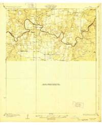
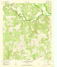
 1927 Grosvenor1927 Print · USGSIn the mid-1920s, the rural landscapes of Brown and Coleman Counties were connected by winding wagon roads and creek fords. Genealogists can trace the early community hubs of Grosvenor and Thrifty alongside schools like Macedonia School and Buffalo School.2 unique versions available
 - 1928 Map of Mercury
 1928 Mercury1928 Print · USGSCentral Texas river country comes to life in the late 1920s as the railroad connects small cattle towns near the four-county junction. Trace family roots at Mercury and Winchell, or locate old landmarks like Elm Grove Church and Holt School.
 - 1928 Map of Waldrip
 1928 Waldrip1928 Print · USGSCrossing the Colorado River in the late 1920s, this area of McCulloch and Coleman Counties was a landscape of remote ranches and vital river fords. Genealogists can locate family landmarks like Chaffin Cem and White Ranch or trace old routes through Military Crossing.2 unique versions available
 - 1931 Map of Baird
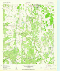
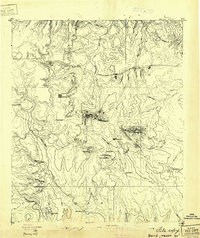 1931 Baird1931 Print · USGSCallahan County ranching and rail life are documented here in the early twentieth century. Genealogists and local historians can trace the foundations of Baird, the Rough Creek P.O., and distinctive landmarks like Caddo Peak and Round Mt.
 - 1931 Map of Stacy
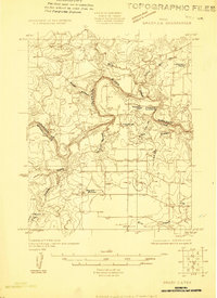
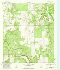
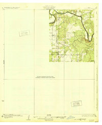 1931 Stacy1931 Print · USGSCentral Texas ranching country comes into focus during the 1920s as the river defines three county lines. Genealogists can locate rural schoolhouses like Hardin Sch and Williams Sch or trace old river fords at Crane Crossing.2 unique versions available
 - 1932 Map of Voss
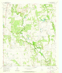
 1932 Voss1932 Print · USGSCentral Texas river life in the mid-1920s is documented here along the winding banks of the Concho River. Genealogists and local historians can trace the community of Leaday and several rural schoolhouses like Liberty Sch and Redwire Sch.2 unique versions available
 - 1932 Map of Baird
 1932 Baird1932 Print · USGSCallahan and Eastland counties appear in the early 1930s, showing the region's transition into the oil and highway era. Genealogists can locate family homes near Belle Plain, Oak Ridge School, and along the Missouri Kansas & Texas railroad.
 - 1950 Map of Mercury
 1950 Mercury1950 Print · USGSMcCulloch County and its neighbors are shown in the mid-twentieth century as the rural landscape transitioned from pioneer roots to modern ranching. Researchers can trace family history through community sites like Cowboy Cemetery, Elm Grove School, and the village of Mercury.2 unique versions available
 - 1954 Map of Brownwood, 1955 Print
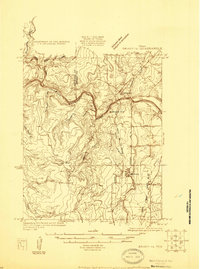
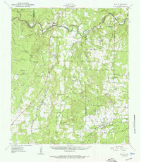
 1954 Brownwood1955 Print · USGSCentral Texas in the early fifties shows a landscape of rail-linked cattle towns and winding river valleys before modern highway expansion. Genealogists and historians can trace family-named peaks and vanished rail stops like Trickham, Santa Anna, and the Brady Mountains.3 unique versions available
 - 1954 Map of Abilene, 1966 Print
 1954 Abilene1966 Print · USGSThe Texas Big Country comes into focus in the mid-1950s as petroleum and new water projects reshape the landscape. Local historians can trace the Butterfield Trail, find the Fort Phantom Hill Ruins, and locate numerous small communities along the Texas & Pacific line.2 unique versions available
 - 1958 Map of Abilene
 1958 Abilene1958 Print · USGSMid-century West Texas comes alive in this survey of the Abilene and Stephenville region during a period of steady oil expansion and military growth. Genealogists and local historians can trace the paths of the Texas & Pacific RR through historic towns, locate the Fort Griffin Ruins, and find smaller settlements like Desdemona and Lueders.
 - 1960 Map of Lake Scarborough, 1962 Print
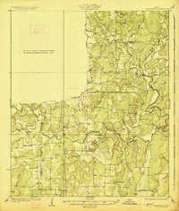
 1960 Lake Scarborough1962 Print · USGSColeman County infrastructure and industry come into focus in the early sixties as the regional water supply and local aviation take center stage. Trace the development of Lake Scarborough and its Filtration Plant, alongside rural landmarks like Morris Field and scattered Oil Wells.2 unique versions available
 - 1960 Map of Coleman NE, 1962 Print
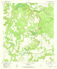
 1960 Coleman NE1962 Print · USGSNortheast Coleman County was a landscape of burgeoning energy production and frontier history at the dawn of the 1960s. Researchers can trace the legacy of the Amzak Morris Oil Field and locate the Camp Colorado historical site near the banks of Jim Ned Creek.3 unique versions available
 - 1960 Map of Burkett, 1962 Print
 1960 Burkett1962 Print · USGSSettlement and industry meet in this pocket of Central Texas at the dawn of the 1960s, showing the rural landscape before modern expansion. Researchers can locate the Burkett townsite, the Cem, and numerous Oil Wells scattered near the Holloway Mountains.
 - 1960 Map of Cross Cut, 1962 Print
 1960 Cross Cut1962 Print · USGSMid-century Texas oil and ranching land come into focus here during the early 1960s. Genealogists and industrial historians can trace the Old Railroad Grade or locate family sites near Dressy Cem and the small community of Cross Cut.2 unique versions available
 - 1960 Map of Webbville, 1962 Print
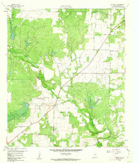
 1960 Webbville1962 Print · USGSThe West Texas landscape at the start of the 1960s reveals a region defined by cattle country and petroleum extraction. Trace local history through the Anzah Morris Oil Field, the settlement of Webbville, and the Adams Cem along the disputed county line.2 unique versions available
 - 1960 Map of Crooked Creek, 1962 Print
 1960 Crooked Creek1962 Print · USGSTexas ranching and oil country come to life in the early 1960s along the winding paths of Jim Ned Creek and Crooked Creek. Researchers can trace old property lines across the 1885 county boundary survey while locating numerous Oil Wells and a Quarry in the hills near Ranger.2 unique versions available
 - 1962 Map of Speck Mountain, 1964 Print
 1962 Speck Mountain1964 Print · USGSIn the early 1960s, Coleman County's landscape was a patchwork of ranching and oil production. Trace the energy history of Rockwood and Speck through numerous Oil Wells, Gravel Pit sites, and the landmark Horseshoe Bend.2 unique versions available
 - 1962 Map of Trickham, 1964 Print
 1962 Trickham1964 Print · USGSEarly 1960s Brown County ranch land is captured here as the landscape transitioned with new water control measures. Genealogists can locate Lee Cem and Smith Cem or trace the path of the Old Railroad Grade near Shields.2 unique versions available
Showing maps 1-25 of 50
Top cities of Coleman County
Frequently asked questions
- What are the different types of historical maps available for Coleman County?
- What is the oldest map of Coleman County?
- Where can I purchase historical maps of Coleman County for my home or office?
- Where can I download high-res historical maps of Coleman County?
- Are there historical topographic maps available for Coleman County?
- Is there historical aerial imagery available for Coleman County?
- Where are historical maps of Coleman County sourced from?