1910s Maps of Colorado County, Texas
Explore 2 historic maps of Colorado County from the 1910s. These maps offer a rare glimpse into what life looked like during the 1910s — showing old roads, neighborhoods, homes, and landmarks that have changed or disappeared over time.
Whether you're researching your family's past, planning a metal detecting trip, or studying how Colorado County's landscape evolved across the 1910s, these high-resolution maps are a powerful tool for exploring the history of this region.
- Focus on a specific era: All maps on this page are from the 1910s, giving you a focused view of this time period.
- See what’s changed: Compare century-old streets, trails, and buildings to today's modern landscape using overlays and satellite layers.
- Research with precision: Use these maps for genealogy, historical research, land use analysis, or educational projects.
- View, download, or print: Maps are fully viewable online in high resolution, and can be downloaded or printed for your own records.
Start exploring Colorado County's history through authentic maps from the 1910s. This is your window into the past.
Colorado County, TX maps
(2)- 1919 Map of Fayettsville
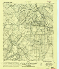 1919 Fayettsville1919 Print · USGSFayette and Colorado counties are captured here in the years following the Great War, showing a landscape defined by the railroad and the river. Researchers can trace the routes of the Missouri Kansas and Texas Railway to historic hubs like Fayetteville and Ellinger.
 - 1919 Map of Schulenburg, 1956 Print
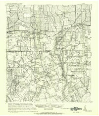 1919 Schulenburg1956 Print · USGSTexas at the close of the Great War was a landscape of rail-connected towns and river crossings. Genealogists can trace family roots through the settlements of High Hill, Dubina, and St. Johns, while following the old fords across the Navidad River.
End of results
Showing maps 1-2 of 2
Top cities of Colorado County
Frequently asked questions
- What are the different types of historical maps available for Colorado County?
- What is the oldest map of Colorado County?
- Where can I purchase historical maps of Colorado County for my home or office?
- Where can I download high-res historical maps of Colorado County?
- Are there historical topographic maps available for Colorado County?
- Is there historical aerial imagery available for Colorado County?
- Where are historical maps of Colorado County sourced from?