1960s Maps of Comanche County, Texas
Explore 17 historic maps of Comanche County from the 1960s. These maps offer a rare glimpse into what life looked like during the 1960s — showing old roads, neighborhoods, homes, and landmarks that have changed or disappeared over time.
Whether you're researching your family's past, planning a metal detecting trip, or studying how Comanche County's landscape evolved across the 1960s, these high-resolution maps are a powerful tool for exploring the history of this region.
- Focus on a specific era: All maps on this page are from the 1960s, giving you a focused view of this time period.
- See what’s changed: Compare century-old streets, trails, and buildings to today's modern landscape using overlays and satellite layers.
- Research with precision: Use these maps for genealogy, historical research, land use analysis, or educational projects.
- View, download, or print: Maps are fully viewable online in high resolution, and can be downloaded or printed for your own records.
Start exploring Comanche County's history through authentic maps from the 1960s. This is your window into the past.
Comanche County, TX maps
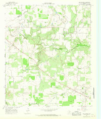
(17)- 1965 Map of Lingleville, 1967 Print
 1965 Lingleville1967 Print · USGSLingleville and the rolling ranchlands of the Erath and Comanche County border are captured here in the mid-1960s. Researchers can trace the path of the Old Railroad Grade or locate family sites near Bethel Cem and Highland Ch.2 unique versions available
 - 1965 Map of Dublin, 1967 Print
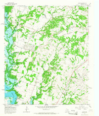
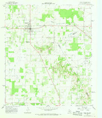
 1965 Dublin1967 Print · USGSDublin is shown as a thriving rail hub in the mid-sixties at the junction of two major western railroads. Researchers can trace the local landscape through landmarks like Memorial Stadium, the Live Oak Cem, and the community of Alexander.
 - 1965 Map of Comyn, 1967 Print
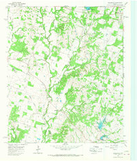
 1965 Comyn1967 Print · USGSThe Comanche and Erath County line in the mid-sixties reveals a landscape defined by new water projects and established rail corridors. Researchers can trace the heritage of Comyn and Roch alongside rural landmarks like Pleasant Home Ch and several early cemeteries.2 unique versions available
 - 1966 Map of Star Mountain, 1968 Print
 1966 Star Mountain1968 Print · USGSThe Comanche and Brown County line comes alive in the mid-1960s, showing a rugged Texas landscape of ridges and ranchland. Trace family landmarks and local history near Star Mountain, the Stag Creek Community Center, and the early Gas Wells of the era.
 - 1966 Map of Sipe Springs, 1968 Print
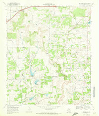
 1966 Sipe Springs1968 Print · USGSSipe Springs and the surrounding Comanche County cattle and oil country are captured here in the mid-1960s. Researchers can trace the path of an Old Railroad Grade or locate family sites at Parker Cem and Sipe Springs Cem.2 unique versions available
 - 1966 Map of Rising Star, 1968 Print
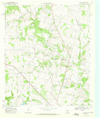
 1966 Rising Star1968 Print · USGSCentral Texas during the mid-sixties reveals a landscape of petroleum development and small crossroads settlements. Genealogists and historians can trace the Old Railroad Grade and locate local landmarks like Wolf Valley Ch and Amity.
 - 1966 Map of Desdemona, 1969 Print
 1966 Desdemona1969 Print · USGSDesdemona and the surrounding ranch lands of Eastland and Erath counties appear here in the mid-sixties as the local oil and gas industry matured. Genealogists and historians can trace the Old Railroad Grade, locate the Howard Cem, and find old landmarks like Mockingbird Hill.
 - 1966 Map of Blanket, 1969 Print
 1966 Blanket1969 Print · USGSThe ranching and rail landscape of Brown and Comanche Counties is captured here in the mid-1960s. Genealogists and local historians can trace family locations through numerous rural burial sites like Logan Valley Cemetery and landmarks such as the Rodeo Ground.2 unique versions available
 - 1968 Map of Rucker, 1972 Print
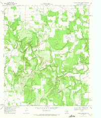
 1968 Rucker1972 Print · USGSComanche County during the late sixties shows a rural landscape in transition, where the Texas Central and an Old Railroad Grade trace the area's history. Genealogists can locate family landmarks such as Oliver Springs Ch, Liberty Ch, and the settlement of Rucker.
 - 1968 Map of Gorman, 1972 Print
 1968 Gorman1972 Print · USGSGorman and its surrounding farmstead country are captured here in the late sixties along the Eastland and Comanche County line. Trace family roots at rural sites like Ellison Spring Cemetery, New Hope Church, and the old railroad grade.2 unique versions available
 - 1969 Map of Duster, 1972 Print
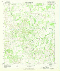
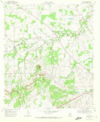
 1969 Duster1972 Print · USGSComanche County's rolling ranchlands and creek beds appear in the late 1960s as the local energy economy began to expand. Researchers can locate numerous family burial sites like Ninevah Cem and rural hubs such as Beattie or the Soda Springs Community Hall.
 - 1969 Map of Sidney, 1972 Print
 1969 Sidney1972 Print · USGSComanche County was a landscape of winding creeks and rising oil interests in the late sixties. You can trace the Atchison Topeka and Santa Fe line or locate family burial sites at Cox Cem, Pendergrass Cem, and Suggs Cem.
 - 1969 Map of Mercers Gap, 1972 Print
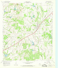
 1969 Mercers Gap1972 Print · USGSThe Comanche and Brown County borderlands come into focus in the late 1960s as a landscape of gaps and railroads. Researchers can trace the Atchison Topeka and Santa Fe line through Watson or locate rural landmarks like White Point Ch and Dudley Airfield.
 - 1969 Map of Newburg, 1972 Print
 1969 Newburg1972 Print · USGSComanche County during the late sixties shows a landscape of small rural communities and evolving water resources. Genealogists and local historians can trace the foundations of Newburg and find landmark country churches like Shiloh Ch and South Leon Ch.
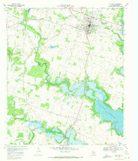
 - 1969 Map of Comanche, 1972 Print
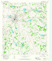
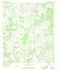
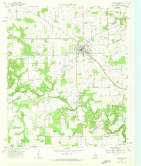
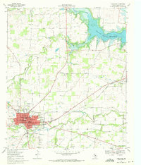 1969 Comanche1972 Print · USGSComanche and its surrounding ranchlands are captured here in the late sixties as the local economy balanced rail transport and new water works. Genealogists can locate several rural landmarks including Zion Hill Cem and Indian Creek Ch.
 - 1969 Map of Hunting Shirt Creek, 1972 Print
 1969 Hunting Shirt Creek1972 Print · USGSCentral Texas ranching and oil country are captured here in the late sixties. Genealogists can locate family burial sites at Jewel Cem and Brown Cem, while tracing the course of Hunting Shirt Creek and the Sabana River.2 unique versions available
 - 1969 Map of De Leon, 1972 Print
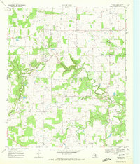
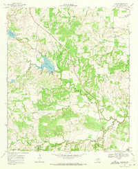
 1969 De Leon1972 Print · USGSDe Leon and its surrounding Comanche County ranchlands are captured here in the late sixties as the Sabana River valley adjusted to the presence of the Proctor Reservoir. Genealogists and local historians can locate Morton Chapel, Ebenezer Cem, and the small settlement at Downing.
End of results
Showing maps 1-17 of 17
Top cities of Comanche County
Frequently asked questions
- What are the different types of historical maps available for Comanche County?
- What is the oldest map of Comanche County?
- Where can I purchase historical maps of Comanche County for my home or office?
- Where can I download high-res historical maps of Comanche County?
- Are there historical topographic maps available for Comanche County?
- Is there historical aerial imagery available for Comanche County?
- Where are historical maps of Comanche County sourced from?