1960s Maps of Valley View, Texas
Explore 2 historic maps of Valley View from the 1960s. These maps offer a rare glimpse into what life looked like during the 1960s — showing old roads, neighborhoods, homes, and landmarks that have changed or disappeared over time.
Whether you're researching your family's past, planning a metal detecting trip, or studying how Valley View's landscape evolved across the 1960s, these high-resolution maps are a powerful tool for exploring the history of this region.
- Focus on a specific era: All maps on this page are from the 1960s, giving you a focused view of this time period.
- See what’s changed: Compare century-old streets, trails, and buildings to today's modern landscape using overlays and satellite layers.
- Research with precision: Use these maps for genealogy, historical research, land use analysis, or educational projects.
- View, download, or print: Maps are fully viewable online in high resolution, and can be downloaded or printed for your own records.
Start exploring Valley View's history through authentic maps from the 1960s. This is your window into the past.
Valley View, TX maps
(2)- 1960 Map of Gainesville South, 1963 Print
 1960 Gainesville South1963 Print · USGSGainesville and the surrounding Texas countryside are captured here in the early sixties as a center of rail commerce and educational growth. Genealogists and local historians can trace family-named sites like Spring Creek Cem or locate early landmarks including Gainesville Jr College and the Refinery.2 unique versions available
 - 1961 Map of Valley View, 1963 Print
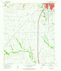
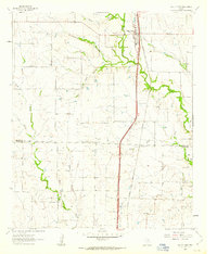 1961 Valley View1963 Print · USGSNorth Texas ranching and rail history come alive in this early 1960s survey of the Cooke and Denton county line. Trace the steam-era path of the Gulf Colorado and Santa Fe through Valley View and locate the quiet settlement of Lois.2 unique versions available
End of results
Showing maps 1-2 of 2
Top cities near Valley View
- Denton historical maps
- Gainesville historical maps
- Sanger historical maps
- Whitesboro historical maps
- Pilot Point historical maps
- Krum historical maps
See more
Frequently asked questions
- What are the different types of historical maps available for Valley View?
- What is the oldest map of Valley View?
- Where can I purchase historical maps of Valley View for my home or office?
- Where can I download high-res historical maps of Valley View?
- Are there historical topographic maps available for Valley View?
- Is there historical aerial imagery available for Valley View?
- Where are historical maps of Valley View sourced from?