1990s Maps of Crockett County, Texas
Explore 2 historic maps of Crockett County from the 1990s. These maps offer a rare glimpse into what life looked like during the 1990s — showing old roads, neighborhoods, homes, and landmarks that have changed or disappeared over time.
Whether you're researching your family's past, planning a metal detecting trip, or studying how Crockett County's landscape evolved across the 1990s, these high-resolution maps are a powerful tool for exploring the history of this region.
- Focus on a specific era: All maps on this page are from the 1990s, giving you a focused view of this time period.
- See what’s changed: Compare century-old streets, trails, and buildings to today's modern landscape using overlays and satellite layers.
- Research with precision: Use these maps for genealogy, historical research, land use analysis, or educational projects.
- View, download, or print: Maps are fully viewable online in high resolution, and can be downloaded or printed for your own records.
Start exploring Crockett County's history through authentic maps from the 1990s. This is your window into the past.
Crockett County, TX maps
(2)- 1993 Map of Rocksprings
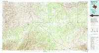 1993 Rocksprings1993 Print · USGSThe Edwards Plateau ranching country is captured here in the early nineties, centered on the high-elevation hub of Rocksprings. Genealogists and local historians can trace the paths of the Old Spanish Road and the intricate draws like Tenmile Draw or Dragoo Hollow.
 - 1994 Map of Sonora
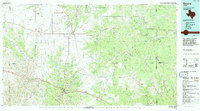 1994 Sonora1994 Print · USGSThe West Texas ranching and energy country around Sonora and Eldorado comes to life in this mid-nineties survey. Researchers can trace the extensive Page Oil and Gas Field network, locate the Caverns of Sonora, and follow the headwaters of the North Llano River.
End of results
Showing maps 1-2 of 2
Top cities of Crockett County
Frequently asked questions
- What are the different types of historical maps available for Crockett County?
- What is the oldest map of Crockett County?
- Where can I purchase historical maps of Crockett County for my home or office?
- Where can I download high-res historical maps of Crockett County?
- Are there historical topographic maps available for Crockett County?
- Is there historical aerial imagery available for Crockett County?
- Where are historical maps of Crockett County sourced from?