1960s Maps of Dallas, Texas
Explore 5 historic maps of Dallas from the 1960s. These maps offer a rare glimpse into what life looked like during the 1960s — showing old roads, neighborhoods, homes, and landmarks that have changed or disappeared over time.
Whether you're researching your family's past, planning a metal detecting trip, or studying how Dallas's landscape evolved across the 1960s, these high-resolution maps are a powerful tool for exploring the history of this region.
- Focus on a specific era: All maps on this page are from the 1960s, giving you a focused view of this time period.
- See what’s changed: Compare century-old streets, trails, and buildings to today's modern landscape using overlays and satellite layers.
- Research with precision: Use these maps for genealogy, historical research, land use analysis, or educational projects.
- View, download, or print: Maps are fully viewable online in high resolution, and can be downloaded or printed for your own records.
Start exploring Dallas's history through authentic maps from the 1960s. This is your window into the past.
Dallas, TX maps
(5)- 1960 Map of Hebron, 1962 Print
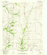 1960 Hebron1962 Print · USGSBefore the suburban sprawl of the late twentieth century, the borderlands of Denton and Collin County remained a landscape of rural schoolhouses and family cemeteries. Trace the early footprints of Hebron and Shepton or locate landmarks like Baccus Cem and the Liberty Ch.6 unique versions available
 - 1963 Map of Lavon, 1964 Print
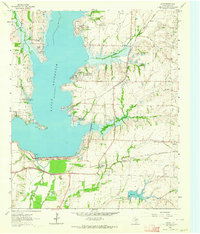 1963 Lavon1964 Print · USGSCollin County enters a new era of development in the 1960s as the rising waters of Lavon Reservoir create new shorelines. Genealogists and local historians can trace early settlements and family plots like Copeville, Nevada, and the IOOF Cem.3 unique versions available
 - 1963 Map of Forney North, 1966 Print
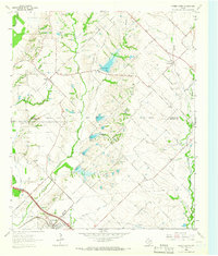 1963 Forney North1966 Print · USGSKaufman and Rockwall Counties are captured here in the early sixties as rural farm life met new infrastructure. You can trace family roots at Chisholm Cem, locate the Mt Rose Ch, or follow the Texas and Pacific rail line through Forney.3 unique versions available
 - 1963 Map of Rockwall, 1966 Print
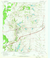 1963 Rockwall1966 Print · USGSRockwall and the surrounding Blackland Prairie terrain are captured here in the early sixties as the region transitioned toward modern development. Researchers can trace family sites near Mt Zion Cem, the old Fate depot area, and the tracks of the Texas and Pacific Railroad.4 unique versions available
 - 1968 Map of Dallas (A), 1970 Print
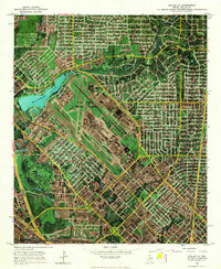 1968 Dallas (A)1970 Print · USGSNorth Dallas at the end of the sixties shows a landscape defined by aviation and rapid urban growth. Trace the runways of Love Field, find the old Drive-In Theater, or locate family sites near Cochran Chapel.
End of results
Showing maps 1-5 of 5
Top cities near Dallas
- Plano historical maps
- Irving historical maps
- Garland historical maps
- Grand Prairie historical maps
- Mesquite historical maps
- Carrollton historical maps
See more
Top neighborhoods of Dallas
- Renner historical maps
- Inwood historical maps
- Gribble historical maps
- Cole historical maps
- Kenwood historical maps
- Ledbetter Hills historical maps
See more
Frequently asked questions
- What are the different types of historical maps available for Dallas?
- What is the oldest map of Dallas?
- Where can I purchase historical maps of Dallas for my home or office?
- Where can I download high-res historical maps of Dallas?
- Are there historical topographic maps available for Dallas?
- Is there historical aerial imagery available for Dallas?
- Where are historical maps of Dallas sourced from?