1990s Maps of Dallas, Texas
Explore 12 historic maps of Dallas from the 1990s. These maps offer a rare glimpse into what life looked like during the 1990s — showing old roads, neighborhoods, homes, and landmarks that have changed or disappeared over time.
Whether you're researching your family's past, planning a metal detecting trip, or studying how Dallas's landscape evolved across the 1990s, these high-resolution maps are a powerful tool for exploring the history of this region.
- Focus on a specific era: All maps on this page are from the 1990s, giving you a focused view of this time period.
- See what’s changed: Compare century-old streets, trails, and buildings to today's modern landscape using overlays and satellite layers.
- Research with precision: Use these maps for genealogy, historical research, land use analysis, or educational projects.
- View, download, or print: Maps are fully viewable online in high resolution, and can be downloaded or printed for your own records.
Start exploring Dallas's history through authentic maps from the 1990s. This is your window into the past.
Dallas, TX maps
(12)- 1995 Map of Oak Cliff, 2001 Print
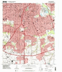 1995 Oak Cliff2001 Print · USGSDallas in the mid-1990s reveals a suburban landscape reaching its southern limits near the Lancaster border. Genealogists and researchers can trace local landmarks like Laurel Land Memorial Park (Cemetery), the historic Fruitdale area, and the former grounds of the Former Strip Mine.
 - 1995 Map of Hutchins, 2001 Print
 1995 Hutchins2001 Print · USGSSoutheastern Dallas and the Trinity River corridor are shown during a time of suburban expansion and industrial transition. Researchers can trace historic sites like Lincoln Memorial Park (Cem), the Hutchins Boys Industrial School, and McCommas Bluff.
 - 1995 Map of Cedar Hill, 2001 Print
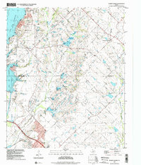
 1995 Cedar Hill2001 Print · USGSThe suburban landscape south of Dallas was undergoing significant growth in the mid-nineties as cities like De Soto and Ovilla expanded. You can trace family roots at the Shiloh Cemetery or locate landmarks like the Mount Lebanon Encampment and Cedarview.
 - 1995 Map of Dallas, 2001 Print
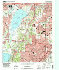
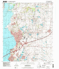
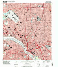 1995 Dallas2001 Print · USGSThe mid-nineties Dallas skyline and its bustling inner suburbs are mapped here during a period of significant urban density. Trace the footprints of Southern Methodist University or locate family history at Greenwood Cem and Cochran Chapel.
 - 1995 Map of Duncanville, 2001 Print
 1995 Duncanville2001 Print · USGSSouthwest Dallas and Duncanville are shown here during the late twentieth-century suburban boom. Researchers can trace local heritage through landmarks like Armstrong Historical Park, the Dallas-Fort Worth National Cemetery, and Trees Cem.
 - 1995 Map of Irving, 2002 Print
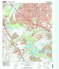
 1995 Irving2002 Print · USGSIrving and West Dallas are shown in the mid-1990s, capturing the area's transition from a rail-and-quarry industrial hub to a dense suburban center. Researchers can trace historic sites like Sowers Cem, the Cistercian Monastery, and the footprint of Texas Stadium.
 - 1995 Map of Rowlett, 2002 Print
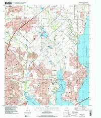 1995 Rowlett2002 Print · USGSRowlett and the surrounding lakefront communities are shown in a period of rapid growth during the mid-nineties. Genealogists and local historians can trace legacy sites like Pleasant Valley Cem and Liberty Grove alongside the developing shores of Lake Ray Hubbard.
 - 1995 Map of Mesquite, 2002 Print
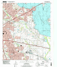 1995 Mesquite2002 Print · USGSMesquite and Garland expand toward the shores of Lake Ray Hubbard during the mid-nineties as suburban development meets older rural settlements. Researchers can trace the evolution of local landmarks from Rose Hill Church to the Long Creek Cemetery and Town East Mall.
 - 1995 Map of Rockwall, 2002 Print
 1995 Rockwall2002 Print · USGSRockwall County witnessed significant suburban expansion toward the end of the century as it oriented itself around the reservoir. Researchers can trace land development and historic family sites like Mt Zion Cem, Zollner Ranch, and the Old Railroad Grade.
 - 1995 Map of Forney North, 2002 Print
 1995 Forney North2002 Print · USGSThe outskirts of Dallas saw rapid transformation in the mid-nineties as suburban growth pushed into Kaufman and Rockwall Counties. Researchers can trace the heritage of early settlers at Peek Cem, Chisholm Cem, and the historic Mt Rose Ch.
 - 1995 Map of White Rock Lake, 2002 Print
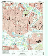
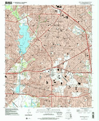 1995 White Rock Lake2002 Print · USGSEast Dallas and the surrounding suburban reaches are shown here in the mid-nineties as the city's residential and educational infrastructure matured. Researchers can locate family landmarks like St Bernard Ch or trace the early foundations of Scyene and Reinhardt.
 - 1995 Map of Britton, 2002 Print
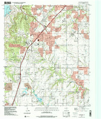
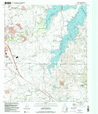 1995 Britton2002 Print · USGSThe Tarrant and Dallas county borderlands were being rapidly transformed by the waters of Joe Pool Lake in the mid-1990s. Local researchers can still find historic landmarks like the Britton settlement, Estes Cem, and Friendship Ch amid the expanding suburbs.
End of results
Showing maps 1-12 of 12
Top cities near Dallas
- Plano historical maps
- Irving historical maps
- Garland historical maps
- Grand Prairie historical maps
- Mesquite historical maps
- Carrollton historical maps
See more
Top neighborhoods of Dallas
- Renner historical maps
- Inwood historical maps
- Gribble historical maps
- Cole historical maps
- Kenwood historical maps
- Ledbetter Hills historical maps
See more
Frequently asked questions
- What are the different types of historical maps available for Dallas?
- What is the oldest map of Dallas?
- Where can I purchase historical maps of Dallas for my home or office?
- Where can I download high-res historical maps of Dallas?
- Are there historical topographic maps available for Dallas?
- Is there historical aerial imagery available for Dallas?
- Where are historical maps of Dallas sourced from?