1990s Maps of DeSoto, Texas
Explore 3 historic maps of DeSoto from the 1990s. These maps offer a rare glimpse into what life looked like during the 1990s — showing old roads, neighborhoods, homes, and landmarks that have changed or disappeared over time.
Whether you're researching your family's past, planning a metal detecting trip, or studying how DeSoto's landscape evolved across the 1990s, these high-resolution maps are a powerful tool for exploring the history of this region.
- Focus on a specific era: All maps on this page are from the 1990s, giving you a focused view of this time period.
- See what’s changed: Compare century-old streets, trails, and buildings to today's modern landscape using overlays and satellite layers.
- Research with precision: Use these maps for genealogy, historical research, land use analysis, or educational projects.
- View, download, or print: Maps are fully viewable online in high resolution, and can be downloaded or printed for your own records.
Start exploring DeSoto's history through authentic maps from the 1990s. This is your window into the past.
DeSoto, TX maps
(3)- 1995 Map of Oak Cliff, 2001 Print
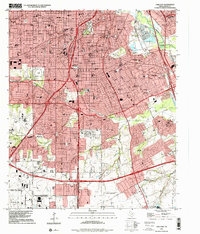 1995 Oak Cliff2001 Print · USGSDallas in the mid-1990s reveals a suburban landscape reaching its southern limits near the Lancaster border. Genealogists and researchers can trace local landmarks like Laurel Land Memorial Park (Cemetery), the historic Fruitdale area, and the former grounds of the Former Strip Mine.
 - 1995 Map of Cedar Hill, 2001 Print
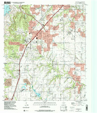 1995 Cedar Hill2001 Print · USGSThe suburban landscape south of Dallas was undergoing significant growth in the mid-nineties as cities like De Soto and Ovilla expanded. You can trace family roots at the Shiloh Cemetery or locate landmarks like the Mount Lebanon Encampment and Cedarview.
 - 1995 Map of Duncanville, 2001 Print
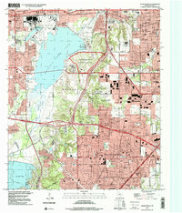 1995 Duncanville2001 Print · USGSSouthwest Dallas and Duncanville are shown here during the late twentieth-century suburban boom. Researchers can trace local heritage through landmarks like Armstrong Historical Park, the Dallas-Fort Worth National Cemetery, and Trees Cem.
End of results
Showing maps 1-3 of 3
Top cities near DeSoto
- Dallas historical maps
- Fort Worth historical maps
- Arlington historical maps
- Irving historical maps
- Garland historical maps
- Grand Prairie historical maps
See more
Top neighborhoods of DeSoto
- Shamrock historical maps
- Summit Parks historical maps
- Pleasant Run historical maps
- De Soto historical maps
Frequently asked questions
- What are the different types of historical maps available for DeSoto?
- What is the oldest map of DeSoto?
- Where can I purchase historical maps of DeSoto for my home or office?
- Where can I download high-res historical maps of DeSoto?
- Are there historical topographic maps available for DeSoto?
- Is there historical aerial imagery available for DeSoto?
- Where are historical maps of DeSoto sourced from?