1940s Maps of Dimmit County, Texas
Explore 8 historic maps of Dimmit County from the 1940s. These maps offer a rare glimpse into what life looked like during the 1940s — showing old roads, neighborhoods, homes, and landmarks that have changed or disappeared over time.
Whether you're researching your family's past, planning a metal detecting trip, or studying how Dimmit County's landscape evolved across the 1940s, these high-resolution maps are a powerful tool for exploring the history of this region.
- Focus on a specific era: All maps on this page are from the 1940s, giving you a focused view of this time period.
- See what’s changed: Compare century-old streets, trails, and buildings to today's modern landscape using overlays and satellite layers.
- Research with precision: Use these maps for genealogy, historical research, land use analysis, or educational projects.
- View, download, or print: Maps are fully viewable online in high resolution, and can be downloaded or printed for your own records.
Start exploring Dimmit County's history through authentic maps from the 1940s. This is your window into the past.
Dimmit County, TX maps
(8)- 1940 Map of Asherton, 1958 Print
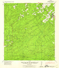 1940 Asherton1958 Print · USGSSouth Texas ranching country comes into focus in this mid-century survey of Dimmit County as it appeared just before the war. Genealogists can trace family holdings and rural landmarks like the Dentonio School, Asheston, and the expansive Briscoe Ranch.2 unique versions available
 - 1940 Map of Velenzuela Creek, 1958 Print
 1940 Velenzuela Creek1958 Print · USGSSouth Texas ranching country at the start of the 1940s shows a landscape of expansive family holdings and seasonal creek beds. Researchers can locate specific sites like Velenzuela Ranch, the Hill Top Inn, and S Cotulla.2 unique versions available
 - 1940 Map of San Loranzo Creek, 1958 Print
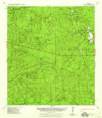
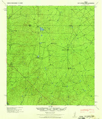 1940 San Loranzo Creek1958 Print · USGSThe ranching country of the Webb and Dimmit borderlands is captured here just before the mid-century, defined by scattered holdings and vital water tanks. Researchers can trace historic property boundaries and find locations like Brown Ranch, the Ruins site, and the Dos Hermanos Peaks.3 unique versions available
 - 1940 Map of Catarina, 1958 Print
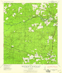
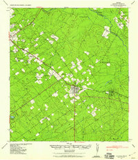 1940 Catarina1958 Print · USGSDimmit County ranching and rail infrastructure are captured here in the early 1940s, just as modern utilities reached the brush country. Genealogists can trace family holdings like the Buckhorn Ranch and Valley Wells along the Central and Gulf (Mo Pac) rail line.2 unique versions available
 - 1940 Map of Cometa, 1958 Print
 1940 Cometa1958 Print · USGSSouthwest Texas ranching country in the early nineteen-forties shows a landscape of large family holdings and seasonal creek beds. Genealogists can trace specific homesteads such as the Sullivan Ranch, F C Anglin Ranch, and the small settlement at Cometa.2 unique versions available
 - 1940 Map of Chupadera, 1959 Print
 1940 Chupadera1959 Print · USGSThe Texas-Mexico borderlands along the Rio Grande are captured here just before the war, showing the remote ranching country of Webb Co. Researchers can locate isolated water sources and early landmarks like Chupadera Ranch, Sullivan Spring, and Cathedral Rock.2 unique versions available
 - 1940 Map of Artesia Wells, 1959 Print
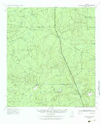
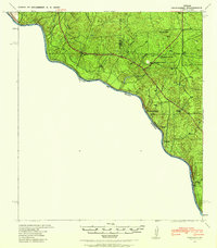
 1940 Artesia Wells1959 Print · USGSLa Salle and Dimmit Counties are captured here just before the Second World War, showing a ranching landscape defined by the Nueces River. Researchers can trace family homesteads like R Armstrong and J Henderson or follow the path of the International-Great Northern Railroad through Artesia Wells.
 - 1941 Map of Botella Creek
 1941 Botella Creek1941 Print · USGSThe Maverick and Dimmit county lines meet in this brush-country landscape during the early years of the Second World War. Researchers can trace the heritage of remote family outposts like Tovar Ranch and Red Ranch or locate vital water sources such as Indio Tank and Lopez Tank.
End of results
Showing maps 1-8 of 8
Top cities of Dimmit County
- Carrizo Springs historical maps
- Asherton historical maps
- Big Wells historical maps
- Catarina historical maps
Frequently asked questions
- What are the different types of historical maps available for Dimmit County?
- What is the oldest map of Dimmit County?
- Where can I purchase historical maps of Dimmit County for my home or office?
- Where can I download high-res historical maps of Dimmit County?
- Are there historical topographic maps available for Dimmit County?
- Is there historical aerial imagery available for Dimmit County?
- Where are historical maps of Dimmit County sourced from?