1980s Maps of Dimmit County, Texas
Explore 21 historic maps of Dimmit County from the 1980s. These maps offer a rare glimpse into what life looked like during the 1980s — showing old roads, neighborhoods, homes, and landmarks that have changed or disappeared over time.
Whether you're researching your family's past, planning a metal detecting trip, or studying how Dimmit County's landscape evolved across the 1980s, these high-resolution maps are a powerful tool for exploring the history of this region.
- Focus on a specific era: All maps on this page are from the 1980s, giving you a focused view of this time period.
- See what’s changed: Compare century-old streets, trails, and buildings to today's modern landscape using overlays and satellite layers.
- Research with precision: Use these maps for genealogy, historical research, land use analysis, or educational projects.
- View, download, or print: Maps are fully viewable online in high resolution, and can be downloaded or printed for your own records.
Start exploring Dimmit County's history through authentic maps from the 1980s. This is your window into the past.
Dimmit County, TX maps
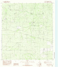
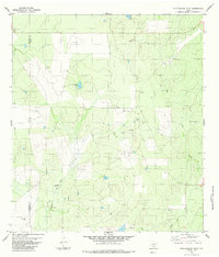
(21)- 1982 Map of Velenzuela Creek
 1982 Velenzuela Creek1982 Print · USGSThe South Texas brush country at the border of Webb and Dimmit Counties comes into focus in the early eighties. Researchers can trace the ranching history and local waterways of this arid landscape, from the Galvan Ranch to the settlements of Bonito and (Rosita).
 - 1982 Map of Blocker Tank
 1982 Blocker Tank1982 Print · USGSIn the early 1980s, this brushland straddling the Dimmit and La Salle county line shows a landscape dedicated to ranching and conservation. Researchers can trace the importance of water at Blocker Tank and Sage Creek or locate remote aviation sites like the Grass Landing Strip.
 - 1982 Map of Asherton
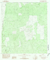
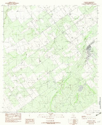 1982 Asherton1982 Print · USGSAsherton was an established South Texas hub in the early eighties, surrounded by a complex network of seasonal creek beds. Researchers can trace the local infrastructure of the era, from the town grid to the Landing Strip and Carrizo Creek drainage.
 - 1982 Map of Dabney Tank
 1982 Dabney Tank1982 Print · USGSDimmit County ranch lands in the early eighties show a landscape defined by seasonal water and essential livestock infrastructure. Researchers can trace the drainage of Appurceon Creek and locate family-named landmarks like Dabney Tank and Pavo Tank.
 - 1982 Map of Mesteno Creek North
 1982 Mesteno Creek North1982 Print · USGSSouth Texas ranch country at the start of the 1980s reveals a landscape defined by its remote watercourses and county lines. Local historians can trace the paths of Pelon Creek, Mesteño Creek, and Las Raices Creek through this intersection of Webb, Dimmit, and La Salle counties.
 - 1982 Map of Landrum Tank
 1982 Landrum Tank1982 Print · USGSSouth Texas ranchlands along the Dimmit and Webb County line are documented in the early eighties, showcasing essential water infrastructure. Researchers can trace cattle operations via stock tanks like Landrum Tank, Old Coma Tank, and the path of Bonito Creek.
 - 1982 Map of Cayetano Creek
 1982 Cayetano Creek1982 Print · USGSThe brush country of Dimmit and Maverick counties comes into focus in the early eighties, showing a landscape shaped by intermittent water and ranching. Trace the paths of Comanche Creek and Pendencia Creek alongside an isolated Landing Strip.
 - 1982 Map of Piloncillo Hill
 1982 Piloncillo Hill1982 Print · USGSThe South Texas brush country along the Dimmit and Webb county line is captured here in the early eighties as a landscape of remote ranching and essential water tanks. Researchers can trace the drainage of Las Tablas Creek and locate family ranch landmarks like Blocker Tank and Piloncillo Hill.
 - 1982 Map of San Pedro Creek
 1982 San Pedro Creek1982 Print · USGSThe South Texas brush country along the Maverick and Dimmit county line is captured here in the early eighties. Researchers can trace the drainage of San Pedro Creek and locate local landmarks like the Gravel Pit and Botella Creek.
 - 1982 Map of Mac Donald Lake
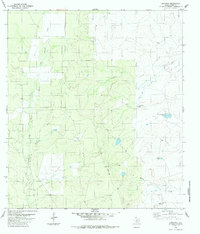
 1982 Mac Donald Lake1982 Print · USGSDimmit County ranch lands are documented here in the early 1980s, centered on the critical water resources of the Nueces basin. Researchers can trace the courses of MacDonald Lake, Soldier Slough, and Appurceon Creek across this brush country terrain.
 - 1982 Map of Catarina
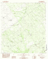
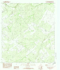
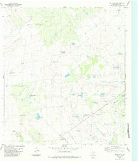
 1982 Catarina1982 Print · USGSDimmit County ranching and rural life are captured in the early 1980s, centered on the small settlement of Catarina. Researchers can trace old water rights and remote landmarks like San Roque Lake, Burro Lake, and the distinctly named So What Tank.
 - 1982 Map of Asherton NW
 1982 Asherton NW1982 Print · USGSDimmit County ranch lands come into focus during the early eighties, revealing the vital water systems of the South Texas Brush Country. Researchers can trace seasonal drainages like Peña Creek and locate ranching landmarks including Gamer Tank and the Landing Strip.
 - 1984 Map of Palo Blanco Tank
 1984 Palo Blanco Tank1984 Print · USGSDimmit and Maverick counties come into focus during the mid-eighties as a region defined by ranching and energy production. Researchers can locate family-named holdings like Yet Ranch or trace the vital water sources at English Tank and Palo Blanco Tank.
 - 1984 Map of Chupadera Creek
 1984 Chupadera Creek1984 Print · USGSThe South Texas borderlands near the Rio Grande appear here in the mid-1980s, showing a landscape of sprawling ranching operations. Researchers can trace the layout of Faith Ranch, locate remote landmarks like Cathedral Rock, and find water sources such as Chupadera Spring.
 - 1984 Map of Farias Tank
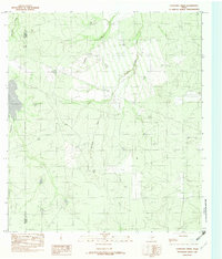
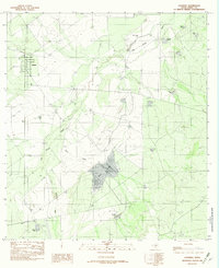
 1984 Farias Tank1984 Print · USGSDimmit County ranching and energy production are at the forefront during the mid-eighties in this South Texas survey. Trace the layout of the Catarina Ranch and find named water features like Farias Tank and San Roque Creek.
 - 1984 Map of Dentonio
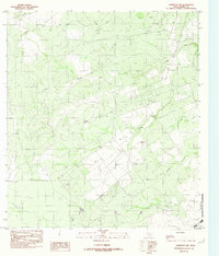
 1984 Dentonio1984 Print · USGSThe South Texas brush country around Dimmit County is shown in the mid-eighties as a landscape defined by ranching and water management. Researchers can trace the layout of Dentonio or locate remote landmarks like Old Tresquilla Tank and the Javelina Windmill.
 - 1984 Map of East Losa Tank
 1984 East Losa Tank1984 Print · USGSThe Dimmit and Webb County line in the mid-1980s was a landscape defined by ranching infrastructure and early energy exploration. Researchers can trace historic water management and land use through landmarks like East Losa Tank, Toro Windmill, and scattered Oil Wells.
 - 1985 Map of Eagle Pass
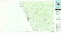 1985 Eagle Pass1985 Print · USGSThe Texas-Mexico borderlands come into focus in the mid-1980s as Eagle Pass grows along the Rio Grande. Genealogists and historians can trace the rail corridor of the Southern Pacific and locate rural communities like Normandy and El Indio.
 - 1985 Map of Cotulla
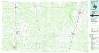
 1985 Cotulla1985 Print · USGSSouth Texas ranching country in the mid-1980s is captured here at a 1:100,000 scale. Genealogists and historians can trace the Missouri Pacific line through Cotulla and Artesia Wells, or locate remote points along Pena Creek and an Old Railroad Grade.2 unique versions available
 - 1985 Map of San Ambrosia Creek
 1985 San Ambrosia Creek1985 Print · USGSMaverick and Dimmit counties are seen here in the mid-1980s, where the international border meets the ranching country of South Texas. Local historians can trace water management sites and remote landmarks like Chupadera Spring, Cathedral Rock, and the Salt Well.
 - 1985 Map of Crystal City
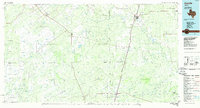
 1985 Crystal City1985 Print · USGSThe Texas Winter Garden region comes into focus during the mid-1980s, detailing a landscape of irrigation, energy, and rail. Genealogists and researchers can trace lineage through rural centers like Big Wells, Winter Haven, and Loma Vista or locate early industrial sites such as the Big Wells Oil Field.2 unique versions available
End of results
Showing maps 1-21 of 21
Top cities of Dimmit County
- Carrizo Springs historical maps
- Asherton historical maps
- Big Wells historical maps
- Catarina historical maps
Frequently asked questions
- What are the different types of historical maps available for Dimmit County?
- What is the oldest map of Dimmit County?
- Where can I purchase historical maps of Dimmit County for my home or office?
- Where can I download high-res historical maps of Dimmit County?
- Are there historical topographic maps available for Dimmit County?
- Is there historical aerial imagery available for Dimmit County?
- Where are historical maps of Dimmit County sourced from?