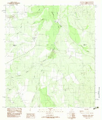
1982 Map of Velenzuela Creek
USGS Topo · Published 1982About this map
Velenzuela Creek and its many tributaries, including Bonito Creek and Chalker Creek, dominate this South Texas landscape along the border of Webb and Dimmit Counties. The terrain is characterized by a network of drainage systems and intermittent water sources such as Farias Tank and Santa Anita Tank, which were essential for ranching operations in this arid region. Small settlements and local landmarks like Bonito and (Rosita) are situated near the waterways, reflecting the historical dependence on these creek beds for habitation and movement. Large landholdings are evident through the presence of the Galvan Ranch, while topographical features like Piloncillo Hill and the Dos Hermanos Peaks provide distinct navigational markers. This survey reveals a landscape of sparse ranching outposts and infrastructure, including the Telephone Tanks, at a time when the region remained largely undeveloped and rural.
Find a feature on this map
21 named features on this map. Tap any name to fly to it.
Don’t see what you’re looking for? This feature index may not catch every label — zoom into the map to look around manually.
Map Details
Editions of this 1982 Velenzuela Creek Map
This is the sole edition of this map. No revisions or reprints were ever made.
Other maps of this area

1929 · Cotulla
USGS Topo · 1:125,000

1932 · Valley Wells
USGS Topo · 1:62,500

1940 · Asherton
USGS Topo · 1:62,500

1940 · Velenzuela Creek
USGS Topo · 1:62,500

1940 · San Loranzo Creek
USGS Topo · 1:62,500

1940 · Catarina
USGS Topo · 1:62,500

1953 · Crystal City
USGS Topo · 1:250,000

1955 · Crystal City
USGS Topo · 1:250,000

1961 · Crystal City
USGS Topo · 1:250,000

1968 · Crystal City
USGS Topo · 1:250,000