
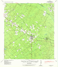
1940 Map of Catarina
USGS Topo · Published 1958About this map
Catarina and the nearby settlement of Kearny anchor this 1940 survey of Dimmit County, revealing a landscape defined by ranching and newly developed infrastructure. The grid of the Central and Gulf (Mo Pac) railroad cuts diagonally through the territory, flanked by numerous small family holdings and ranch headquarters such as the Buckhorn Ranch and the G & M Ranch. This era shows the expansion of utilities across the rural landscape, marked by the prominent lines of the Light and Power Company. To the north, the Nueces River serves as a vital water source, with historic points like Perkins Crossing providing transit across the waterway. Numerous small drainage creeks like Moro Creek and Apparicion Creek feed into larger reservoirs such as San Roque Lake, illustrating the careful management of water in this South Texas brush country.
Find a feature on this map
43 named features on this map. Tap any name to fly to it.
Don’t see what you’re looking for? This feature index may not catch every label — zoom into the map to look around manually.
Map Details
Editions of this 1940 Catarina Map
2 editions found
Other maps of this area

1925 · San Roque Lake 1-a
USGS Topo · 1:48,000

1927 · Bart
USGS Topo · 1:62,500

1929 · Cotulla
USGS Topo · 1:125,000

1932 · Valley Wells
USGS Topo · 1:62,500

1939 · Carrizo Springs
USGS Topo · 1:62,500

1939 · Big Wells
USGS Topo · 1:62,500

1940 · Asherton
USGS Topo · 1:62,500

1940 · Velenzuela Creek
USGS Topo · 1:62,500

1940 · San Loranzo Creek
USGS Topo · 1:62,500

1940 · Artesia Wells
USGS Topo · 1:62,500