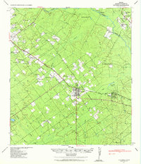
1940 Map of Catarina
USGS Topo · Published 1965About this map
The Catarina townsite serves as the hub for this South Texas cattle country, situated where the Gulf Coast Lines (Mo Pac) railroad intersects the central highway. The landscape is defined by the brushy drainage basins of the Nueces River and several significant creeks, including Espantosa Creek and San Roque Creek. Large ranching operations dominate the area, marked by family names such as the Buckhorn Ranch, the W L Moody Ranch, and the G & M Ranch. Local genealogy is well-preserved through the numerous individual homesteads and farmsteads plotted across the terrain, from Eardly Farm in the northwest to Valley Wells in the northeast. Water management for livestock is evident in the presence of San Roque Lake and Catarina Lake, alongside a scatter of unnamed water tanks. A rare mention of Ruins west of town hints at earlier structural history in this arid Dimmit County environment.
Find a feature on this map
45 named features on this map. Tap any name to fly to it.
Don’t see what you’re looking for? This feature index may not catch every label — zoom into the map to look around manually.
Map Details
Editions of this 1940 Catarina Map
2 editions found
Other maps of this area

1925 · San Roque Lake 1-a
USGS Topo · 1:48,000

1927 · Bart
USGS Topo · 1:62,500

1929 · Cotulla
USGS Topo · 1:125,000

1932 · Valley Wells
USGS Topo · 1:62,500

1939 · Carrizo Springs
USGS Topo · 1:62,500

1939 · Big Wells
USGS Topo · 1:62,500

1940 · Asherton
USGS Topo · 1:62,500

1940 · Velenzuela Creek
USGS Topo · 1:62,500

1940 · San Loranzo Creek
USGS Topo · 1:62,500

1940 · Catarina
USGS Topo · 1:62,500